You are here: Home > Network List > O2 - Oklahoma Consolidated Temporary Seismic Networks Stations List
> Station FW01 Cuddy Creek, Oklahoma, USA > Earthquake Result Viewer
FW01 Cuddy Creek, Oklahoma, USA - Earthquake Result Viewer
| Earthquake location: |
Southern Argentina |
| Earthquake latitude/longitude: |
-38.2/-70.4 |
| Earthquake time(UTC): |
2023/07/17 (198) 03:05:10 GMT |
| Earthquake Depth: |
171 km |
| Earthquake Magnitude: |
6.6 mww |
| Earthquake Catalog/Contributor: |
NEIC PDE/us |
|
| Network: |
O2 Oklahoma Consolidated Temporary Seismic Networks |
| Station: |
FW01 Cuddy Creek, Oklahoma, USA |
| Lat/Lon: |
36.49 N/98.94 W |
| Elevation: |
431 m |
|
| Distance: |
78.9 deg |
| Az: |
336.876 deg |
| Baz: |
157.417 deg |
| Ray Param: |
0.04893101 |
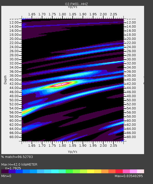
| Estimated Moho Depth: |
42.0 km |
| Estimated Crust Vp/Vs: |
1.79 |
| Assumed Crust Vp: |
6.426 km/s |
| Estimated Crust Vs: |
3.585 km/s |
| Estimated Crust Poisson's Ratio: |
0.27 |
|
| Radial Match: |
96.52783 % |
| Radial Bump: |
261 |
| Transverse Match: |
88.490425 % |
| Transverse Bump: |
400 |
| SOD ConfigId: |
30536071 |
| Insert Time: |
2023-07-31 03:32:35.707 +0000 |
| GWidth: |
2.5 |
| Max Bumps: |
400 |
| Tol: |
0.001 |
|

Signal To Noise
| Channel | StoN | STA | LTA |
| O2:FW01: :HHZ:20230717T03:16:23.979988Z | 62.261635 | 4.653687E-6 | 7.474405E-8 |
| O2:FW01: :HHN:20230717T03:16:23.979988Z | 32.23001 | 1.8333084E-6 | 5.6882023E-8 |
| O2:FW01: :HHE:20230717T03:16:23.979988Z | 13.928939 | 1.2110402E-6 | 8.694418E-8 |
| Arrivals |
| Ps | 5.3 SECOND |
| PpPs | 18 SECOND |
| PsPs/PpSs | 23 SECOND |


