You are here: Home > Network List > O2 - Oklahoma Consolidated Temporary Seismic Networks Stations List
> Station PW13 Pawnee, Oklahoma, USA > Earthquake Result Viewer
PW13 Pawnee, Oklahoma, USA - Earthquake Result Viewer
| Earthquake location: |
Southern Argentina |
| Earthquake latitude/longitude: |
-38.2/-70.4 |
| Earthquake time(UTC): |
2023/07/17 (198) 03:05:10 GMT |
| Earthquake Depth: |
171 km |
| Earthquake Magnitude: |
6.6 mww |
| Earthquake Catalog/Contributor: |
NEIC PDE/us |
|
| Network: |
O2 Oklahoma Consolidated Temporary Seismic Networks |
| Station: |
PW13 Pawnee, Oklahoma, USA |
| Lat/Lon: |
36.33 N/96.82 W |
| Elevation: |
290 m |
|
| Distance: |
78.1 deg |
| Az: |
338.436 deg |
| Baz: |
158.983 deg |
| Ray Param: |
0.049463082 |
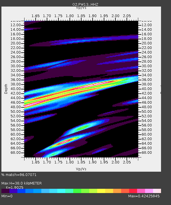
| Estimated Moho Depth: |
38.0 km |
| Estimated Crust Vp/Vs: |
1.90 |
| Assumed Crust Vp: |
6.483 km/s |
| Estimated Crust Vs: |
3.407 km/s |
| Estimated Crust Poisson's Ratio: |
0.31 |
|
| Radial Match: |
96.07071 % |
| Radial Bump: |
344 |
| Transverse Match: |
80.05831 % |
| Transverse Bump: |
400 |
| SOD ConfigId: |
30536071 |
| Insert Time: |
2023-07-31 03:33:05.667 +0000 |
| GWidth: |
2.5 |
| Max Bumps: |
400 |
| Tol: |
0.001 |
|

Signal To Noise
| Channel | StoN | STA | LTA |
| O2:PW13: :HHZ:20230717T03:16:19.664986Z | 92.20265 | 5.634754E-6 | 6.111271E-8 |
| O2:PW13: :HHN:20230717T03:16:19.664986Z | 23.721859 | 2.2992726E-6 | 9.692633E-8 |
| O2:PW13: :HHE:20230717T03:16:19.664986Z | 10.282715 | 8.9234675E-7 | 8.678124E-8 |
| Arrivals |
| Ps | 5.4 SECOND |
| PpPs | 17 SECOND |
| PsPs/PpSs | 22 SECOND |


