You are here: Home > Network List > SV - Servicio Nacional de Estudios Territoriales (SNET), El Salvador Stations List
> Station SNET Servicio Nacional de Estudios Territoriales, El Salvador > Earthquake Result Viewer
SNET Servicio Nacional de Estudios Territoriales, El Salvador - Earthquake Result Viewer
| Earthquake location: |
Southern Argentina |
| Earthquake latitude/longitude: |
-38.2/-70.4 |
| Earthquake time(UTC): |
2023/07/17 (198) 03:05:10 GMT |
| Earthquake Depth: |
171 km |
| Earthquake Magnitude: |
6.6 mww |
| Earthquake Catalog/Contributor: |
NEIC PDE/us |
|
| Network: |
SV Servicio Nacional de Estudios Territoriales (SNET), El Salvador |
| Station: |
SNET Servicio Nacional de Estudios Territoriales, El Salvador |
| Lat/Lon: |
13.69 N/89.23 W |
| Elevation: |
775 m |
|
| Distance: |
54.5 deg |
| Az: |
337.315 deg |
| Baz: |
161.781 deg |
| Ray Param: |
0.06479625 |
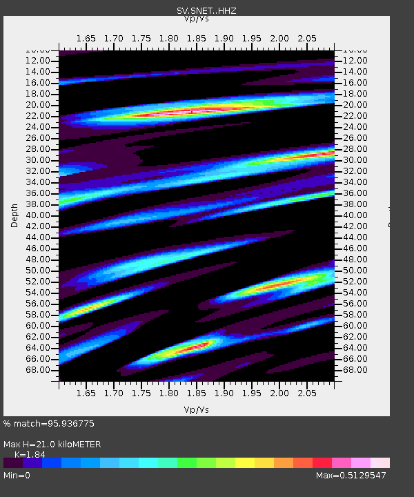
| Estimated Moho Depth: |
21.0 km |
| Estimated Crust Vp/Vs: |
1.84 |
| Assumed Crust Vp: |
6.048 km/s |
| Estimated Crust Vs: |
3.287 km/s |
| Estimated Crust Poisson's Ratio: |
0.29 |
|
| Radial Match: |
95.936775 % |
| Radial Bump: |
400 |
| Transverse Match: |
89.49091 % |
| Transverse Bump: |
400 |
| SOD ConfigId: |
30536071 |
| Insert Time: |
2023-07-31 03:39:02.201 +0000 |
| GWidth: |
2.5 |
| Max Bumps: |
400 |
| Tol: |
0.001 |
|

Signal To Noise
| Channel | StoN | STA | LTA |
| SV:SNET: :HHZ:20230717T03:13:50.568001Z | 17.83603 | 6.770619E-6 | 3.7960353E-7 |
| SV:SNET: :HHN:20230717T03:13:50.568001Z | 8.806257 | 3.9177353E-6 | 4.4488087E-7 |
| SV:SNET: :HHE:20230717T03:13:50.568001Z | 1.9114057 | 8.746347E-7 | 4.5758716E-7 |
| Arrivals |
| Ps | 3.0 SECOND |
| PpPs | 9.4 SECOND |
| PsPs/PpSs | 12 SECOND |


