You are here: Home > Network List > TX - Texas Seismological Network Stations List
> Station PB28 Culberson South > Earthquake Result Viewer
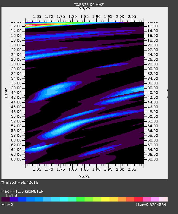
PB28 Culberson South - Earthquake Result Viewer
| Earthquake location: |
Southern Argentina |
| Earthquake latitude/longitude: |
-38.2/-70.4 |
| Earthquake time(UTC): |
2023/07/17 (198) 03:05:10 GMT |
| Earthquake Depth: |
171 km |
| Earthquake Magnitude: |
6.6 mww |
| Earthquake Catalog/Contributor: |
NEIC PDE/us |
|
| Network: |
TX Texas Seismological Network |
| Station: |
PB28 Culberson South |
| Lat/Lon: |
31.67 N/104.50 W |
| Elevation: |
1204 m |
|
| Distance: |
76.4 deg |
| Az: |
330.521 deg |
| Baz: |
152.951 deg |
| Ray Param: |
0.0505636 |
| Estimated Moho Depth: |
11.5 km |
| Estimated Crust Vp/Vs: |
1.60 |
| Assumed Crust Vp: |
6.361 km/s |
| Estimated Crust Vs: |
3.975 km/s |
| Estimated Crust Poisson's Ratio: |
0.18 |
|
| Radial Match: |
96.42618 % |
| Radial Bump: |
373 |
| Transverse Match: |
84.44371 % |
| Transverse Bump: |
400 |
| SOD ConfigId: |
30536071 |
| Insert Time: |
2023-07-31 03:41:24.072 +0000 |
| GWidth: |
2.5 |
| Max Bumps: |
400 |
| Tol: |
0.001 |
|

Signal To Noise
| Channel | StoN | STA | LTA |
| TX:PB28:00:HHZ:20230717T03:16:10.570015Z | 119.171165 | 3.474891E-6 | 2.9158825E-8 |
| TX:PB28:00:HH1:20230717T03:16:10.570015Z | 39.6642 | 1.0051342E-6 | 2.5341093E-8 |
| TX:PB28:00:HH2:20230717T03:16:10.570015Z | 19.014153 | 4.9576045E-7 | 2.6073234E-8 |
| Arrivals |
| Ps | 1.1 SECOND |
| PpPs | 4.5 SECOND |
| PsPs/PpSs | 5.7 SECOND |


