You are here: Home > Network List > GS - US Geological Survey Networks Stations List
> Station KAN13 Rinehart Farm > Earthquake Result Viewer
KAN13 Rinehart Farm - Earthquake Result Viewer
*The percent match for this event was below the threshold and hence no stack was calculated.
| Earthquake location: |
North Atlantic Ocean |
| Earthquake latitude/longitude: |
15.6/-49.9 |
| Earthquake time(UTC): |
2018/11/27 (331) 19:34:46 GMT |
| Earthquake Depth: |
10 km |
| Earthquake Magnitude: |
5.5 Mww |
| Earthquake Catalog/Contributor: |
NEIC PDE/us |
|
| Network: |
GS US Geological Survey Networks |
| Station: |
KAN13 Rinehart Farm |
| Lat/Lon: |
37.01 N/97.48 W |
| Elevation: |
340 m |
|
| Distance: |
47.1 deg |
| Az: |
306.265 deg |
| Baz: |
103.893 deg |
| Ray Param: |
$rayparam |
*The percent match for this event was below the threshold and hence was not used in the summary stack. |
|
| Radial Match: |
19.633005 % |
| Radial Bump: |
400 |
| Transverse Match: |
19.033325 % |
| Transverse Bump: |
400 |
| SOD ConfigId: |
3165032 |
| Insert Time: |
2018-12-11 19:42:06.213 +0000 |
| GWidth: |
2.5 |
| Max Bumps: |
400 |
| Tol: |
0.001 |
|
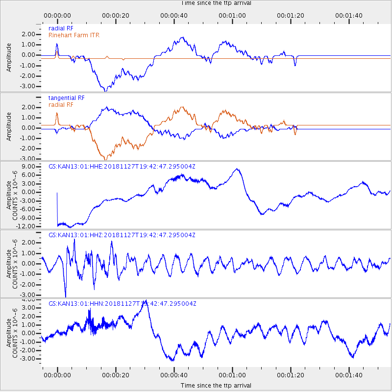
Signal To Noise
| Channel | StoN | STA | LTA |
| GS:KAN13:01:HHZ:20181127T19:42:47.295004Z | 4.409053 | 1.1287059E-6 | 2.5599738E-7 |
| GS:KAN13:01:HHN:20181127T19:42:47.295004Z | 1.3537924 | 2.3822276E-6 | 1.7596699E-6 |
| GS:KAN13:01:HHE:20181127T19:42:47.295004Z | 1.9087259 | 7.554629E-6 | 3.957943E-6 |
| Arrivals |
| Ps | |
| PpPs | |
| PsPs/PpSs | |


