You are here: Home > Network List > US - United States National Seismic Network Stations List
> Station WVOR Wild Horse Valley, Oregon, USA > Earthquake Result Viewer
WVOR Wild Horse Valley, Oregon, USA - Earthquake Result Viewer
| Earthquake location: |
Southern Argentina |
| Earthquake latitude/longitude: |
-38.2/-70.4 |
| Earthquake time(UTC): |
2023/07/17 (198) 03:05:10 GMT |
| Earthquake Depth: |
171 km |
| Earthquake Magnitude: |
6.6 mww |
| Earthquake Catalog/Contributor: |
NEIC PDE/us |
|
| Network: |
US United States National Seismic Network |
| Station: |
WVOR Wild Horse Valley, Oregon, USA |
| Lat/Lon: |
42.43 N/118.64 W |
| Elevation: |
1344 m |
|
| Distance: |
91.5 deg |
| Az: |
326.454 deg |
| Baz: |
143.972 deg |
| Ray Param: |
0.041532427 |
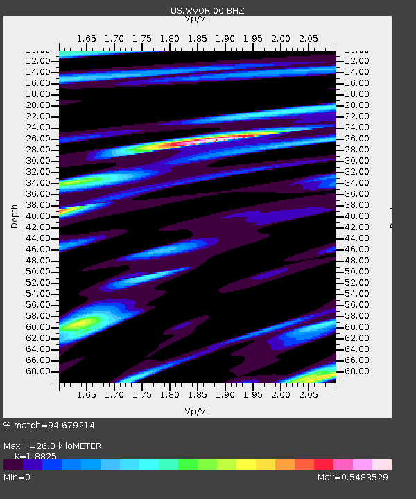
| Estimated Moho Depth: |
26.0 km |
| Estimated Crust Vp/Vs: |
1.88 |
| Assumed Crust Vp: |
6.279 km/s |
| Estimated Crust Vs: |
3.335 km/s |
| Estimated Crust Poisson's Ratio: |
0.30 |
|
| Radial Match: |
94.679214 % |
| Radial Bump: |
400 |
| Transverse Match: |
86.103424 % |
| Transverse Bump: |
400 |
| SOD ConfigId: |
30536071 |
| Insert Time: |
2023-07-31 03:45:43.670 +0000 |
| GWidth: |
2.5 |
| Max Bumps: |
400 |
| Tol: |
0.001 |
|
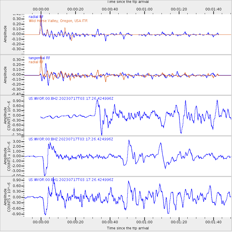
Signal To Noise
| Channel | StoN | STA | LTA |
| US:WVOR:00:BHZ:20230717T03:17:26.424996Z | 30.053925 | 2.117921E-6 | 7.04707E-8 |
| US:WVOR:00:BH1:20230717T03:17:26.424996Z | 9.713233 | 4.656653E-7 | 4.794133E-8 |
| US:WVOR:00:BH2:20230717T03:17:26.424996Z | 9.144439 | 5.326017E-7 | 5.824323E-8 |
| Arrivals |
| Ps | 3.7 SECOND |
| PpPs | 12 SECOND |
| PsPs/PpSs | 15 SECOND |


