You are here: Home > Network List > GS - US Geological Survey Networks Stations List
> Station OK031 S. Brethren Rd., Cushing, OK, USA > Earthquake Result Viewer
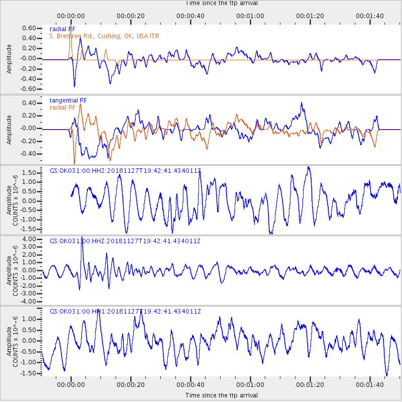
OK031 S. Brethren Rd., Cushing, OK, USA - Earthquake Result Viewer
*The percent match for this event was below the threshold and hence no stack was calculated.
| Earthquake location: |
North Atlantic Ocean |
| Earthquake latitude/longitude: |
15.6/-49.9 |
| Earthquake time(UTC): |
2018/11/27 (331) 19:34:46 GMT |
| Earthquake Depth: |
10 km |
| Earthquake Magnitude: |
5.5 Mww |
| Earthquake Catalog/Contributor: |
NEIC PDE/us |
|
| Network: |
GS US Geological Survey Networks |
| Station: |
OK031 S. Brethren Rd., Cushing, OK, USA |
| Lat/Lon: |
35.95 N/96.84 W |
| Elevation: |
290 m |
|
| Distance: |
46.4 deg |
| Az: |
305.021 deg |
| Baz: |
103.419 deg |
| Ray Param: |
$rayparam |
*The percent match for this event was below the threshold and hence was not used in the summary stack. |
|
| Radial Match: |
45.369038 % |
| Radial Bump: |
400 |
| Transverse Match: |
28.698109 % |
| Transverse Bump: |
400 |
| SOD ConfigId: |
3165032 |
| Insert Time: |
2018-12-11 19:42:17.017 +0000 |
| GWidth: |
2.5 |
| Max Bumps: |
400 |
| Tol: |
0.001 |
|
Signal To Noise
| Channel | StoN | STA | LTA |
| GS:OK031:00:HHZ:20181127T19:42:41.434011Z | 3.725567 | 1.4776889E-6 | 3.9663462E-7 |
| GS:OK031:00:HH1:20181127T19:42:41.434011Z | 0.3597941 | 4.352755E-7 | 1.2097904E-6 |
| GS:OK031:00:HH2:20181127T19:42:41.434011Z | 1.2746265 | 9.1988625E-7 | 7.216908E-7 |
| Arrivals |
| Ps | |
| PpPs | |
| PsPs/PpSs | |


