You are here: Home > Network List > US - United States National Seismic Network Stations List
> Station MSO Missoula, Montana, USA > Earthquake Result Viewer
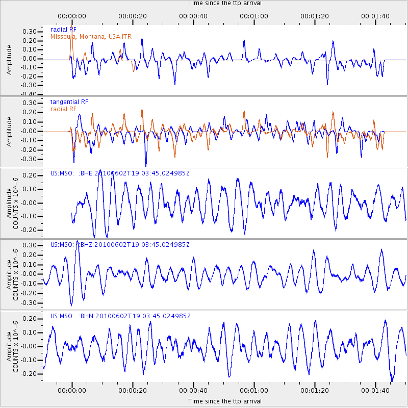
MSO Missoula, Montana, USA - Earthquake Result Viewer
*The percent match for this event was below the threshold and hence no stack was calculated.
| Earthquake location: |
Vanuatu Islands |
| Earthquake latitude/longitude: |
-13.7/166.6 |
| Earthquake time(UTC): |
2010/06/02 (153) 18:51:07 GMT |
| Earthquake Depth: |
35 km |
| Earthquake Magnitude: |
5.6 MB, 5.2 MS, 5.6 MW, 5.5 MW |
| Earthquake Catalog/Contributor: |
WHDF/NEIC |
|
| Network: |
US United States National Seismic Network |
| Station: |
MSO Missoula, Montana, USA |
| Lat/Lon: |
46.83 N/113.94 W |
| Elevation: |
1264 m |
|
| Distance: |
92.8 deg |
| Az: |
42.522 deg |
| Baz: |
253.054 deg |
| Ray Param: |
$rayparam |
*The percent match for this event was below the threshold and hence was not used in the summary stack. |
|
| Radial Match: |
53.835182 % |
| Radial Bump: |
400 |
| Transverse Match: |
68.21255 % |
| Transverse Bump: |
400 |
| SOD ConfigId: |
317696 |
| Insert Time: |
2010-09-19 07:39:34.104 +0000 |
| GWidth: |
2.5 |
| Max Bumps: |
400 |
| Tol: |
0.001 |
|
Signal To Noise
| Channel | StoN | STA | LTA |
| US:MSO: :BHZ:20100602T19:03:45.024985Z | 3.142806 | 2.1966821E-7 | 6.989557E-8 |
| US:MSO: :BHN:20100602T19:03:45.024985Z | 0.55675185 | 4.703532E-8 | 8.4481655E-8 |
| US:MSO: :BHE:20100602T19:03:45.024985Z | 0.61099136 | 7.405764E-8 | 1.2120898E-7 |
| Arrivals |
| Ps | |
| PpPs | |
| PsPs/PpSs | |


