You are here: Home > Network List > TA - USArray Transportable Network (new EarthScope stations) Stations List
> Station G03D McMinnville, OR, USA > Earthquake Result Viewer
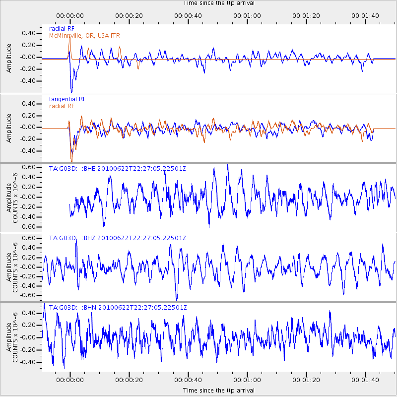
G03D McMinnville, OR, USA - Earthquake Result Viewer
*The percent match for this event was below the threshold and hence no stack was calculated.
| Earthquake location: |
Fiji Islands Region |
| Earthquake latitude/longitude: |
-19.2/-177.6 |
| Earthquake time(UTC): |
2010/06/22 (173) 22:16:20 GMT |
| Earthquake Depth: |
562 km |
| Earthquake Magnitude: |
5.8 MW, 5.1 MB, 5.8 MW |
| Earthquake Catalog/Contributor: |
WHDF/NEIC |
|
| Network: |
TA USArray Transportable Network (new EarthScope stations) |
| Station: |
G03D McMinnville, OR, USA |
| Lat/Lon: |
45.21 N/123.26 W |
| Elevation: |
222 m |
|
| Distance: |
80.9 deg |
| Az: |
35.544 deg |
| Baz: |
231.005 deg |
| Ray Param: |
$rayparam |
*The percent match for this event was below the threshold and hence was not used in the summary stack. |
|
| Radial Match: |
45.057972 % |
| Radial Bump: |
400 |
| Transverse Match: |
46.194336 % |
| Transverse Bump: |
400 |
| SOD ConfigId: |
318645 |
| Insert Time: |
2010-11-29 18:44:40.384 +0000 |
| GWidth: |
2.5 |
| Max Bumps: |
400 |
| Tol: |
0.001 |
|
Signal To Noise
| Channel | StoN | STA | LTA |
| TA:G03D: :BHZ:20100622T22:27:05.22501Z | 1.2020018 | 2.0855815E-7 | 1.7350902E-7 |
| TA:G03D: :BHN:20100622T22:27:05.22501Z | 1.2318999 | 2.3832766E-7 | 1.9346349E-7 |
| TA:G03D: :BHE:20100622T22:27:05.22501Z | 1.2118839 | 2.534435E-7 | 2.0913181E-7 |
| Arrivals |
| Ps | |
| PpPs | |
| PsPs/PpSs | |


