You are here: Home > Network List > TA - USArray Transportable Network (new EarthScope stations) Stations List
> Station O33A Hebron, NE, USA > Earthquake Result Viewer
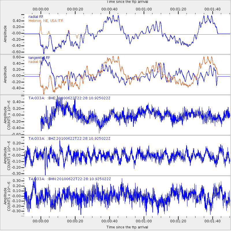
O33A Hebron, NE, USA - Earthquake Result Viewer
*The percent match for this event was below the threshold and hence no stack was calculated.
| Earthquake location: |
Fiji Islands Region |
| Earthquake latitude/longitude: |
-19.2/-177.6 |
| Earthquake time(UTC): |
2010/06/22 (173) 22:16:20 GMT |
| Earthquake Depth: |
562 km |
| Earthquake Magnitude: |
5.8 MW, 5.1 MB, 5.8 MW |
| Earthquake Catalog/Contributor: |
WHDF/NEIC |
|
| Network: |
TA USArray Transportable Network (new EarthScope stations) |
| Station: |
O33A Hebron, NE, USA |
| Lat/Lon: |
40.08 N/97.58 W |
| Elevation: |
480 m |
|
| Distance: |
94.8 deg |
| Az: |
49.308 deg |
| Baz: |
249.044 deg |
| Ray Param: |
$rayparam |
*The percent match for this event was below the threshold and hence was not used in the summary stack. |
|
| Radial Match: |
39.30063 % |
| Radial Bump: |
400 |
| Transverse Match: |
53.171368 % |
| Transverse Bump: |
400 |
| SOD ConfigId: |
318645 |
| Insert Time: |
2010-11-29 18:46:02.672 +0000 |
| GWidth: |
2.5 |
| Max Bumps: |
400 |
| Tol: |
0.001 |
|
Signal To Noise
| Channel | StoN | STA | LTA |
| TA:O33A: :BHZ:20100622T22:28:10.925022Z | 1.0036119 | 9.6920324E-8 | 9.6571505E-8 |
| TA:O33A: :BHN:20100622T22:28:10.925022Z | 0.66242063 | 9.605669E-8 | 1.450086E-7 |
| TA:O33A: :BHE:20100622T22:28:10.925022Z | 1.1033078 | 2.4039943E-7 | 2.1788973E-7 |
| Arrivals |
| Ps | |
| PpPs | |
| PsPs/PpSs | |


