You are here: Home > Network List > AV - Alaska Volcano Observatory Stations List
> Station SPBG Barrier Glacier, Mount Spurr, Alaska > Earthquake Result Viewer
SPBG Barrier Glacier, Mount Spurr, Alaska - Earthquake Result Viewer
| Earthquake location: |
Off Coast Of Jalisco, Mexico |
| Earthquake latitude/longitude: |
18.0/-105.7 |
| Earthquake time(UTC): |
2023/07/18 (199) 10:13:49 GMT |
| Earthquake Depth: |
10 km |
| Earthquake Magnitude: |
5.7 mww |
| Earthquake Catalog/Contributor: |
NEIC PDE/us |
|
| Network: |
AV Alaska Volcano Observatory |
| Station: |
SPBG Barrier Glacier, Mount Spurr, Alaska |
| Lat/Lon: |
61.26 N/152.37 W |
| Elevation: |
1087 m |
|
| Distance: |
54.2 deg |
| Az: |
334.328 deg |
| Baz: |
121.473 deg |
| Ray Param: |
0.06561157 |
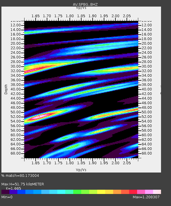
| Estimated Moho Depth: |
51.75 km |
| Estimated Crust Vp/Vs: |
1.66 |
| Assumed Crust Vp: |
6.566 km/s |
| Estimated Crust Vs: |
3.944 km/s |
| Estimated Crust Poisson's Ratio: |
0.22 |
|
| Radial Match: |
80.173004 % |
| Radial Bump: |
400 |
| Transverse Match: |
67.44451 % |
| Transverse Bump: |
400 |
| SOD ConfigId: |
30536071 |
| Insert Time: |
2023-08-01 10:22:14.927 +0000 |
| GWidth: |
2.5 |
| Max Bumps: |
400 |
| Tol: |
0.001 |
|

Signal To Noise
| Channel | StoN | STA | LTA |
| AV:SPBG: :BHZ:20230718T10:22:43.980011Z | 2.3651533 | 1.0547644E-7 | 4.4596025E-8 |
| AV:SPBG: :BHN:20230718T10:22:43.980011Z | 1.173541 | 5.585767E-8 | 4.7597545E-8 |
| AV:SPBG: :BHE:20230718T10:22:43.980011Z | 2.7920902 | 1.540286E-7 | 5.516605E-8 |
| Arrivals |
| Ps | 5.6 SECOND |
| PpPs | 20 SECOND |
| PsPs/PpSs | 25 SECOND |


