You are here: Home > Network List > LD - Lamont-Doherty Cooperative Seismographic Network Stations List
> Station GEDE Greenville, DE, USA > Earthquake Result Viewer
GEDE Greenville, DE, USA - Earthquake Result Viewer
| Earthquake location: |
Off Coast Of Jalisco, Mexico |
| Earthquake latitude/longitude: |
18.0/-105.7 |
| Earthquake time(UTC): |
2023/07/18 (199) 10:13:49 GMT |
| Earthquake Depth: |
10 km |
| Earthquake Magnitude: |
5.7 mww |
| Earthquake Catalog/Contributor: |
NEIC PDE/us |
|
| Network: |
LD Lamont-Doherty Cooperative Seismographic Network |
| Station: |
GEDE Greenville, DE, USA |
| Lat/Lon: |
39.81 N/75.64 W |
| Elevation: |
105 m |
|
| Distance: |
33.9 deg |
| Az: |
43.87 deg |
| Baz: |
238.885 deg |
| Ray Param: |
0.07801619 |
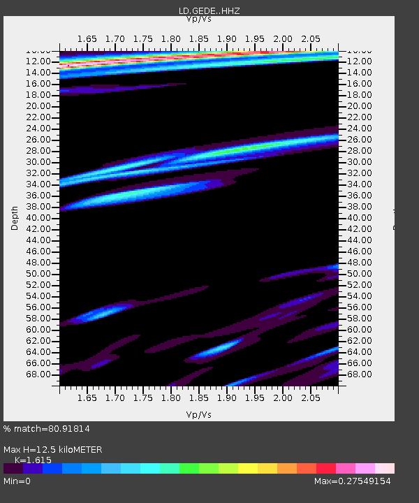
| Estimated Moho Depth: |
12.5 km |
| Estimated Crust Vp/Vs: |
1.62 |
| Assumed Crust Vp: |
6.287 km/s |
| Estimated Crust Vs: |
3.893 km/s |
| Estimated Crust Poisson's Ratio: |
0.19 |
|
| Radial Match: |
80.91814 % |
| Radial Bump: |
308 |
| Transverse Match: |
56.69842 % |
| Transverse Bump: |
400 |
| SOD ConfigId: |
30536071 |
| Insert Time: |
2023-08-01 10:31:23.303 +0000 |
| GWidth: |
2.5 |
| Max Bumps: |
400 |
| Tol: |
0.001 |
|

Signal To Noise
| Channel | StoN | STA | LTA |
| LD:GEDE: :HHZ:20230718T10:20:01.48999Z | 5.649744 | 3.6487475E-7 | 6.458253E-8 |
| LD:GEDE: :HHN:20230718T10:20:01.48999Z | 2.4698079 | 1.5322956E-7 | 6.204109E-8 |
| LD:GEDE: :HHE:20230718T10:20:01.48999Z | 2.3249161 | 1.8642328E-7 | 8.018495E-8 |
| Arrivals |
| Ps | 1.3 SECOND |
| PpPs | 4.8 SECOND |
| PsPs/PpSs | 6.1 SECOND |


