You are here: Home > Network List > AK - Alaska Regional Network Stations List
> Station F21K Alatna River, AK, USA > Earthquake Result Viewer
F21K Alatna River, AK, USA - Earthquake Result Viewer
| Earthquake location: |
Off Coast Of Central America |
| Earthquake latitude/longitude: |
12.8/-88.1 |
| Earthquake time(UTC): |
2023/07/19 (200) 00:22:07 GMT |
| Earthquake Depth: |
70 km |
| Earthquake Magnitude: |
6.5 mww |
| Earthquake Catalog/Contributor: |
NEIC PDE/us |
|
| Network: |
AK Alaska Regional Network |
| Station: |
F21K Alatna River, AK, USA |
| Lat/Lon: |
67.22 N/153.48 W |
| Elevation: |
597 m |
|
| Distance: |
68.8 deg |
| Az: |
337.694 deg |
| Baz: |
108.044 deg |
| Ray Param: |
0.055899505 |
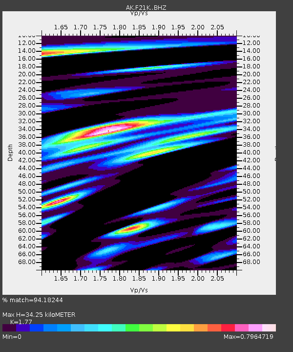
| Estimated Moho Depth: |
34.25 km |
| Estimated Crust Vp/Vs: |
1.77 |
| Assumed Crust Vp: |
6.455 km/s |
| Estimated Crust Vs: |
3.647 km/s |
| Estimated Crust Poisson's Ratio: |
0.27 |
|
| Radial Match: |
94.18244 % |
| Radial Bump: |
400 |
| Transverse Match: |
91.045616 % |
| Transverse Bump: |
400 |
| SOD ConfigId: |
30536071 |
| Insert Time: |
2023-08-02 00:25:55.918 +0000 |
| GWidth: |
2.5 |
| Max Bumps: |
400 |
| Tol: |
0.001 |
|

Signal To Noise
| Channel | StoN | STA | LTA |
| AK:F21K: :BHZ:20230719T00:32:33.799979Z | 13.436285 | 6.1333054E-7 | 4.564733E-8 |
| AK:F21K: :BHN:20230719T00:32:33.799979Z | 3.084549 | 7.7265405E-8 | 2.5049173E-8 |
| AK:F21K: :BHE:20230719T00:32:33.799979Z | 10.463893 | 2.2978537E-7 | 2.1959837E-8 |
| Arrivals |
| Ps | 4.2 SECOND |
| PpPs | 14 SECOND |
| PsPs/PpSs | 18 SECOND |


