You are here: Home > Network List > AK - Alaska Regional Network Stations List
> Station FIRE Fire Island, AK, USA > Earthquake Result Viewer
FIRE Fire Island, AK, USA - Earthquake Result Viewer
| Earthquake location: |
Off Coast Of Central America |
| Earthquake latitude/longitude: |
12.8/-88.1 |
| Earthquake time(UTC): |
2023/07/19 (200) 00:22:07 GMT |
| Earthquake Depth: |
70 km |
| Earthquake Magnitude: |
6.5 mww |
| Earthquake Catalog/Contributor: |
NEIC PDE/us |
|
| Network: |
AK Alaska Regional Network |
| Station: |
FIRE Fire Island, AK, USA |
| Lat/Lon: |
61.14 N/150.22 W |
| Elevation: |
62 m |
|
| Distance: |
65.5 deg |
| Az: |
331.901 deg |
| Baz: |
108.735 deg |
| Ray Param: |
0.058032226 |
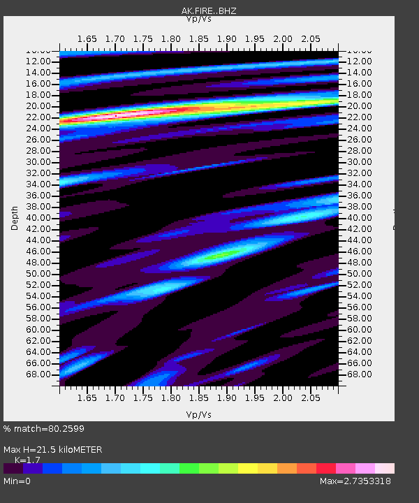
| Estimated Moho Depth: |
21.5 km |
| Estimated Crust Vp/Vs: |
1.70 |
| Assumed Crust Vp: |
6.302 km/s |
| Estimated Crust Vs: |
3.707 km/s |
| Estimated Crust Poisson's Ratio: |
0.24 |
|
| Radial Match: |
80.2599 % |
| Radial Bump: |
400 |
| Transverse Match: |
61.1799 % |
| Transverse Bump: |
400 |
| SOD ConfigId: |
30536071 |
| Insert Time: |
2023-08-02 00:25:58.989 +0000 |
| GWidth: |
2.5 |
| Max Bumps: |
400 |
| Tol: |
0.001 |
|

Signal To Noise
| Channel | StoN | STA | LTA |
| AK:FIRE: :BHZ:20230719T00:32:13.067984Z | 9.844598 | 1.6478607E-6 | 1.673873E-7 |
| AK:FIRE: :BHN:20230719T00:32:13.067984Z | 0.86398065 | 2.3540646E-7 | 2.7246728E-7 |
| AK:FIRE: :BHE:20230719T00:32:13.067984Z | 3.306157 | 4.5823214E-7 | 1.3859963E-7 |
| Arrivals |
| Ps | 2.5 SECOND |
| PpPs | 8.8 SECOND |
| PsPs/PpSs | 11 SECOND |


