You are here: Home > Network List > AK - Alaska Regional Network Stations List
> Station GHO Gloryhole, AK, USA > Earthquake Result Viewer
GHO Gloryhole, AK, USA - Earthquake Result Viewer
| Earthquake location: |
Off Coast Of Central America |
| Earthquake latitude/longitude: |
12.8/-88.1 |
| Earthquake time(UTC): |
2023/07/19 (200) 00:22:07 GMT |
| Earthquake Depth: |
70 km |
| Earthquake Magnitude: |
6.5 mww |
| Earthquake Catalog/Contributor: |
NEIC PDE/us |
|
| Network: |
AK Alaska Regional Network |
| Station: |
GHO Gloryhole, AK, USA |
| Lat/Lon: |
61.77 N/148.92 W |
| Elevation: |
1038 m |
|
| Distance: |
65.2 deg |
| Az: |
332.784 deg |
| Baz: |
110.237 deg |
| Ray Param: |
0.05828857 |
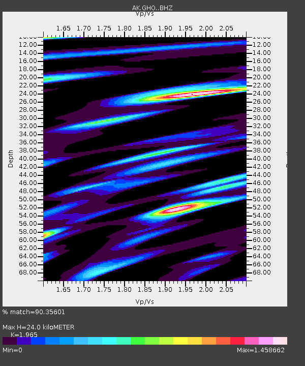
| Estimated Moho Depth: |
24.0 km |
| Estimated Crust Vp/Vs: |
1.97 |
| Assumed Crust Vp: |
6.566 km/s |
| Estimated Crust Vs: |
3.342 km/s |
| Estimated Crust Poisson's Ratio: |
0.33 |
|
| Radial Match: |
90.35601 % |
| Radial Bump: |
400 |
| Transverse Match: |
77.78492 % |
| Transverse Bump: |
400 |
| SOD ConfigId: |
30536071 |
| Insert Time: |
2023-08-02 00:26:10.054 +0000 |
| GWidth: |
2.5 |
| Max Bumps: |
400 |
| Tol: |
0.001 |
|

Signal To Noise
| Channel | StoN | STA | LTA |
| AK:GHO: :BHZ:20230719T00:32:10.668021Z | 16.76039 | 8.14863E-7 | 4.8618382E-8 |
| AK:GHO: :BHN:20230719T00:32:10.668021Z | 8.142439 | 2.942284E-7 | 3.613517E-8 |
| AK:GHO: :BHE:20230719T00:32:10.668021Z | 5.319009 | 2.3856737E-7 | 4.4851845E-8 |
| Arrivals |
| Ps | 3.7 SECOND |
| PpPs | 10 SECOND |
| PsPs/PpSs | 14 SECOND |


