You are here: Home > Network List > US - United States National Seismic Network Stations List
> Station WMOK Wichita Mountains, Oklahoma, USA > Earthquake Result Viewer
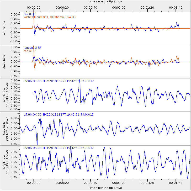
WMOK Wichita Mountains, Oklahoma, USA - Earthquake Result Viewer
*The percent match for this event was below the threshold and hence no stack was calculated.
| Earthquake location: |
North Atlantic Ocean |
| Earthquake latitude/longitude: |
15.6/-49.9 |
| Earthquake time(UTC): |
2018/11/27 (331) 19:34:46 GMT |
| Earthquake Depth: |
10 km |
| Earthquake Magnitude: |
5.5 Mww |
| Earthquake Catalog/Contributor: |
NEIC PDE/us |
|
| Network: |
US United States National Seismic Network |
| Station: |
WMOK Wichita Mountains, Oklahoma, USA |
| Lat/Lon: |
34.74 N/98.78 W |
| Elevation: |
486 m |
|
| Distance: |
47.7 deg |
| Az: |
302.944 deg |
| Baz: |
100.884 deg |
| Ray Param: |
$rayparam |
*The percent match for this event was below the threshold and hence was not used in the summary stack. |
|
| Radial Match: |
47.945248 % |
| Radial Bump: |
379 |
| Transverse Match: |
43.611332 % |
| Transverse Bump: |
400 |
| SOD ConfigId: |
3165032 |
| Insert Time: |
2018-12-11 19:46:22.079 +0000 |
| GWidth: |
2.5 |
| Max Bumps: |
400 |
| Tol: |
0.001 |
|
Signal To Noise
| Channel | StoN | STA | LTA |
| US:WMOK:00:BHZ:20181127T19:42:51.549001Z | 2.08207 | 6.591967E-7 | 3.166064E-7 |
| US:WMOK:00:BH1:20181127T19:42:51.549001Z | 1.1472782 | 2.1268966E-7 | 1.8538628E-7 |
| US:WMOK:00:BH2:20181127T19:42:51.549001Z | 1.815973 | 3.9900294E-7 | 2.1971854E-7 |
| Arrivals |
| Ps | |
| PpPs | |
| PsPs/PpSs | |


