You are here: Home > Network List > AV - Alaska Volcano Observatory Stations List
> Station SPNN North Nagishlamina, Mount Spurr, Alaska > Earthquake Result Viewer
SPNN North Nagishlamina, Mount Spurr, Alaska - Earthquake Result Viewer
| Earthquake location: |
Off Coast Of Central America |
| Earthquake latitude/longitude: |
12.8/-88.1 |
| Earthquake time(UTC): |
2023/07/19 (200) 00:22:07 GMT |
| Earthquake Depth: |
70 km |
| Earthquake Magnitude: |
6.5 mww |
| Earthquake Catalog/Contributor: |
NEIC PDE/us |
|
| Network: |
AV Alaska Volcano Observatory |
| Station: |
SPNN North Nagishlamina, Mount Spurr, Alaska |
| Lat/Lon: |
61.37 N/152.70 W |
| Elevation: |
1666 m |
|
| Distance: |
66.7 deg |
| Az: |
331.737 deg |
| Baz: |
106.494 deg |
| Ray Param: |
0.057246584 |
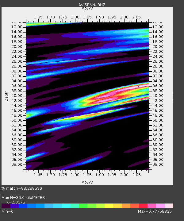
| Estimated Moho Depth: |
36.0 km |
| Estimated Crust Vp/Vs: |
2.06 |
| Assumed Crust Vp: |
6.566 km/s |
| Estimated Crust Vs: |
3.191 km/s |
| Estimated Crust Poisson's Ratio: |
0.35 |
|
| Radial Match: |
88.288536 % |
| Radial Bump: |
400 |
| Transverse Match: |
87.70409 % |
| Transverse Bump: |
400 |
| SOD ConfigId: |
30536071 |
| Insert Time: |
2023-08-02 00:32:33.548 +0000 |
| GWidth: |
2.5 |
| Max Bumps: |
400 |
| Tol: |
0.001 |
|

Signal To Noise
| Channel | StoN | STA | LTA |
| AV:SPNN: :BHZ:20230719T00:32:20.819998Z | 16.690342 | 6.222788E-7 | 3.7283762E-8 |
| AV:SPNN: :BHN:20230719T00:32:20.819998Z | 2.1901786 | 8.857843E-8 | 4.0443474E-8 |
| AV:SPNN: :BHE:20230719T00:32:20.819998Z | 7.355717 | 2.577345E-7 | 3.5038664E-8 |
| Arrivals |
| Ps | 6.0 SECOND |
| PpPs | 16 SECOND |
| PsPs/PpSs | 22 SECOND |


