You are here: Home > Network List > AU - Australian Seismological Centre Stations List
> Station FORT Forrest, Western Australia > Earthquake Result Viewer
FORT Forrest, Western Australia - Earthquake Result Viewer
| Earthquake location: |
Solomon Islands |
| Earthquake latitude/longitude: |
-10.6/161.4 |
| Earthquake time(UTC): |
2010/06/26 (177) 05:30:19 GMT |
| Earthquake Depth: |
35 km |
| Earthquake Magnitude: |
6.4 MB, 6.8 MS, 6.7 MW, 6.6 MW |
| Earthquake Catalog/Contributor: |
WHDF/NEIC |
|
| Network: |
AU Australian Seismological Centre |
| Station: |
FORT Forrest, Western Australia |
| Lat/Lon: |
30.78 S/128.06 E |
| Elevation: |
165 m |
|
| Distance: |
36.9 deg |
| Az: |
232.085 deg |
| Baz: |
64.308 deg |
| Ray Param: |
0.07636523 |
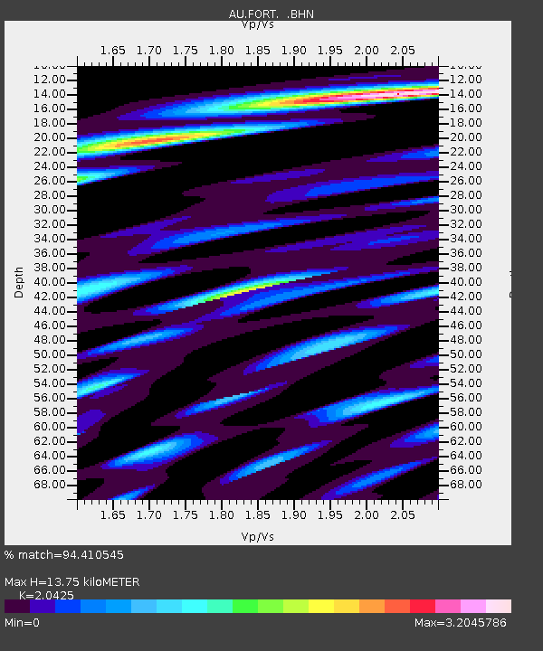
| Estimated Moho Depth: |
13.75 km |
| Estimated Crust Vp/Vs: |
2.04 |
| Assumed Crust Vp: |
6.479 km/s |
| Estimated Crust Vs: |
3.172 km/s |
| Estimated Crust Poisson's Ratio: |
0.34 |
|
| Radial Match: |
94.410545 % |
| Radial Bump: |
400 |
| Transverse Match: |
68.62161 % |
| Transverse Bump: |
400 |
| SOD ConfigId: |
318645 |
| Insert Time: |
2010-11-29 19:23:17.609 +0000 |
| GWidth: |
2.5 |
| Max Bumps: |
400 |
| Tol: |
0.001 |
|

Signal To Noise
| Channel | StoN | STA | LTA |
| AU:FORT: :BHZ:20100626T05:36:54.400004Z | 10.585097 | 2.9216149E-6 | 2.760121E-7 |
| AU:FORT: :BHN:20100626T05:36:54.400004Z | 1.7407812 | 5.9564644E-7 | 3.4217192E-7 |
| AU:FORT: :BHE:20100626T05:36:54.400004Z | 2.8698533 | 1.1648158E-6 | 4.0587992E-7 |
| Arrivals |
| Ps | 2.4 SECOND |
| PpPs | 6.0 SECOND |
| PsPs/PpSs | 8.4 SECOND |


