You are here: Home > Network List > AU - Australian Seismological Centre Stations List
> Station TOO Toolangi, Victoria > Earthquake Result Viewer
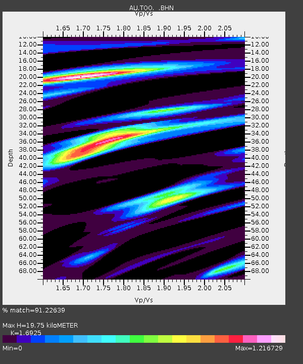
TOO Toolangi, Victoria - Earthquake Result Viewer
| Earthquake location: |
Solomon Islands |
| Earthquake latitude/longitude: |
-10.6/161.4 |
| Earthquake time(UTC): |
2010/06/26 (177) 05:30:19 GMT |
| Earthquake Depth: |
35 km |
| Earthquake Magnitude: |
6.4 MB, 6.8 MS, 6.7 MW, 6.6 MW |
| Earthquake Catalog/Contributor: |
WHDF/NEIC |
|
| Network: |
AU Australian Seismological Centre |
| Station: |
TOO Toolangi, Victoria |
| Lat/Lon: |
37.57 S/145.49 E |
| Elevation: |
604 m |
|
| Distance: |
30.4 deg |
| Az: |
205.55 deg |
| Baz: |
32.25 deg |
| Ray Param: |
0.07930093 |
| Estimated Moho Depth: |
19.75 km |
| Estimated Crust Vp/Vs: |
1.69 |
| Assumed Crust Vp: |
6.577 km/s |
| Estimated Crust Vs: |
3.886 km/s |
| Estimated Crust Poisson's Ratio: |
0.23 |
|
| Radial Match: |
91.22639 % |
| Radial Bump: |
356 |
| Transverse Match: |
72.91813 % |
| Transverse Bump: |
400 |
| SOD ConfigId: |
318645 |
| Insert Time: |
2010-11-29 19:23:29.361 +0000 |
| GWidth: |
2.5 |
| Max Bumps: |
400 |
| Tol: |
0.001 |
|

Signal To Noise
| Channel | StoN | STA | LTA |
| AU:TOO: :BHZ:20100626T05:35:58.370005Z | 4.270774 | 1.9211925E-6 | 4.4984645E-7 |
| AU:TOO: :BHN:20100626T05:35:58.370005Z | 3.3729858 | 1.2941748E-6 | 3.8368816E-7 |
| AU:TOO: :BHE:20100626T05:35:58.370005Z | 2.3457906 | 7.125452E-7 | 3.037548E-7 |
| Arrivals |
| Ps | 2.3 SECOND |
| PpPs | 7.4 SECOND |
| PsPs/PpSs | 9.7 SECOND |


