You are here: Home > Network List > N4 - Central and EAstern US Network Stations List
> Station G65A Princeton, ME, USA > Earthquake Result Viewer
G65A Princeton, ME, USA - Earthquake Result Viewer
| Earthquake location: |
Off Coast Of Central America |
| Earthquake latitude/longitude: |
12.8/-88.1 |
| Earthquake time(UTC): |
2023/07/19 (200) 00:22:07 GMT |
| Earthquake Depth: |
70 km |
| Earthquake Magnitude: |
6.5 mww |
| Earthquake Catalog/Contributor: |
NEIC PDE/us |
|
| Network: |
N4 Central and EAstern US Network |
| Station: |
G65A Princeton, ME, USA |
| Lat/Lon: |
45.20 N/67.56 W |
| Elevation: |
78 m |
|
| Distance: |
36.7 deg |
| Az: |
24.539 deg |
| Baz: |
214.958 deg |
| Ray Param: |
0.07634491 |
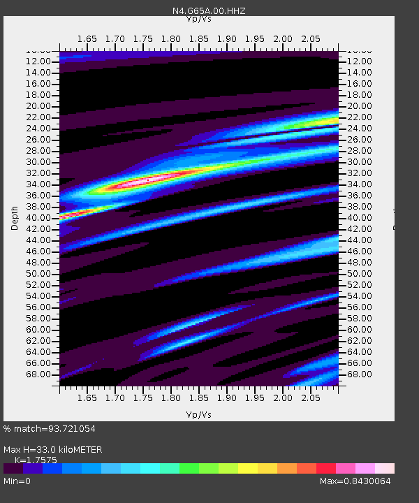
| Estimated Moho Depth: |
33.0 km |
| Estimated Crust Vp/Vs: |
1.76 |
| Assumed Crust Vp: |
6.419 km/s |
| Estimated Crust Vs: |
3.652 km/s |
| Estimated Crust Poisson's Ratio: |
0.26 |
|
| Radial Match: |
93.721054 % |
| Radial Bump: |
255 |
| Transverse Match: |
86.903725 % |
| Transverse Bump: |
400 |
| SOD ConfigId: |
30536071 |
| Insert Time: |
2023-08-02 00:49:01.201 +0000 |
| GWidth: |
2.5 |
| Max Bumps: |
400 |
| Tol: |
0.001 |
|

Signal To Noise
| Channel | StoN | STA | LTA |
| N4:G65A:00:HHZ:20230719T00:28:37.83901Z | 15.944422 | 2.1038877E-6 | 1.3195132E-7 |
| N4:G65A:00:HH1:20230719T00:28:37.83901Z | 8.114268 | 9.970767E-7 | 1.2287943E-7 |
| N4:G65A:00:HH2:20230719T00:28:37.83901Z | 6.3902907 | 8.0531345E-7 | 1.2602142E-7 |
| Arrivals |
| Ps | 4.2 SECOND |
| PpPs | 13 SECOND |
| PsPs/PpSs | 17 SECOND |


