You are here: Home > Network List > US - United States National Seismic Network Stations List
> Station HAWA Hanford, Washington, USA > Earthquake Result Viewer
HAWA Hanford, Washington, USA - Earthquake Result Viewer
| Earthquake location: |
Off Coast Of Central America |
| Earthquake latitude/longitude: |
12.8/-88.1 |
| Earthquake time(UTC): |
2023/07/19 (200) 00:22:07 GMT |
| Earthquake Depth: |
70 km |
| Earthquake Magnitude: |
6.5 mww |
| Earthquake Catalog/Contributor: |
NEIC PDE/us |
|
| Network: |
US United States National Seismic Network |
| Station: |
HAWA Hanford, Washington, USA |
| Lat/Lon: |
46.39 N/119.53 W |
| Elevation: |
364 m |
|
| Distance: |
42.7 deg |
| Az: |
327.849 deg |
| Baz: |
131.415 deg |
| Ray Param: |
0.072824076 |
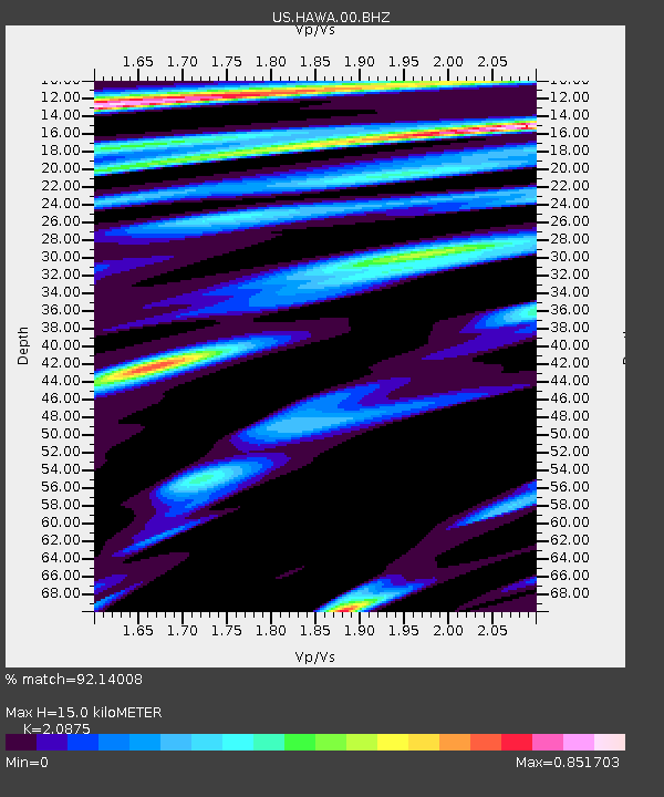
| Estimated Moho Depth: |
15.0 km |
| Estimated Crust Vp/Vs: |
2.09 |
| Assumed Crust Vp: |
6.419 km/s |
| Estimated Crust Vs: |
3.075 km/s |
| Estimated Crust Poisson's Ratio: |
0.35 |
|
| Radial Match: |
92.14008 % |
| Radial Bump: |
400 |
| Transverse Match: |
75.23371 % |
| Transverse Bump: |
400 |
| SOD ConfigId: |
30536071 |
| Insert Time: |
2023-08-02 00:57:03.045 +0000 |
| GWidth: |
2.5 |
| Max Bumps: |
400 |
| Tol: |
0.001 |
|
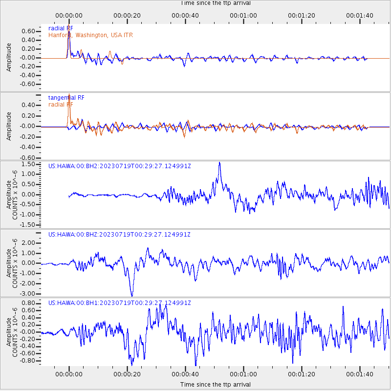
Signal To Noise
| Channel | StoN | STA | LTA |
| US:HAWA:00:BHZ:20230719T00:29:27.124991Z | 6.1228013 | 2.878455E-7 | 4.7012062E-8 |
| US:HAWA:00:BH1:20230719T00:29:27.124991Z | 4.0802417 | 1.2761613E-7 | 3.127661E-8 |
| US:HAWA:00:BH2:20230719T00:29:27.124991Z | 3.1106637 | 1.4110238E-7 | 4.5360856E-8 |
| Arrivals |
| Ps | 2.7 SECOND |
| PpPs | 6.8 SECOND |
| PsPs/PpSs | 9.5 SECOND |


