You are here: Home > Network List > CI - Caltech Regional Seismic Network Stations List
> Station PLM Palomar, Palomar Mountain, CA, USA > Earthquake Result Viewer
PLM Palomar, Palomar Mountain, CA, USA - Earthquake Result Viewer
| Earthquake location: |
Solomon Islands |
| Earthquake latitude/longitude: |
-10.6/161.4 |
| Earthquake time(UTC): |
2010/06/26 (177) 05:30:19 GMT |
| Earthquake Depth: |
35 km |
| Earthquake Magnitude: |
6.4 MB, 6.8 MS, 6.7 MW, 6.6 MW |
| Earthquake Catalog/Contributor: |
WHDF/NEIC |
|
| Network: |
CI Caltech Regional Seismic Network |
| Station: |
PLM Palomar, Palomar Mountain, CA, USA |
| Lat/Lon: |
33.35 N/116.86 W |
| Elevation: |
1691 m |
|
| Distance: |
88.9 deg |
| Az: |
55.929 deg |
| Baz: |
256.636 deg |
| Ray Param: |
0.04217459 |
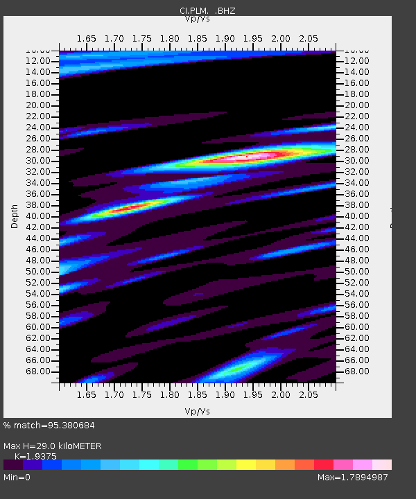
| Estimated Moho Depth: |
29.0 km |
| Estimated Crust Vp/Vs: |
1.94 |
| Assumed Crust Vp: |
6.264 km/s |
| Estimated Crust Vs: |
3.233 km/s |
| Estimated Crust Poisson's Ratio: |
0.32 |
|
| Radial Match: |
95.380684 % |
| Radial Bump: |
400 |
| Transverse Match: |
89.46231 % |
| Transverse Bump: |
400 |
| SOD ConfigId: |
318645 |
| Insert Time: |
2010-11-29 19:25:28.302 +0000 |
| GWidth: |
2.5 |
| Max Bumps: |
400 |
| Tol: |
0.001 |
|

Signal To Noise
| Channel | StoN | STA | LTA |
| CI:PLM: :BHZ:20100626T05:42:39.145029Z | 10.895029 | 1.255692E-6 | 1.1525366E-7 |
| CI:PLM: :BHN:20100626T05:42:39.145029Z | 1.4694297 | 1.6306856E-7 | 1.10974035E-7 |
| CI:PLM: :BHE:20100626T05:42:39.145029Z | 4.0505056 | 4.4758133E-7 | 1.1050012E-7 |
| Arrivals |
| Ps | 4.4 SECOND |
| PpPs | 13 SECOND |
| PsPs/PpSs | 18 SECOND |


