You are here: Home > Network List > UW - Pacific Northwest Regional Seismic Network Stations List
> Station CDF Cedar Flats, MSH, WA, USA > Earthquake Result Viewer
CDF Cedar Flats, MSH, WA, USA - Earthquake Result Viewer
| Earthquake location: |
Off Coast Of Central America |
| Earthquake latitude/longitude: |
12.8/-88.1 |
| Earthquake time(UTC): |
2023/07/19 (200) 00:22:07 GMT |
| Earthquake Depth: |
70 km |
| Earthquake Magnitude: |
6.5 mww |
| Earthquake Catalog/Contributor: |
NEIC PDE/us |
|
| Network: |
UW Pacific Northwest Regional Seismic Network |
| Station: |
CDF Cedar Flats, MSH, WA, USA |
| Lat/Lon: |
46.12 N/122.05 W |
| Elevation: |
772 m |
|
| Distance: |
43.8 deg |
| Az: |
325.911 deg |
| Baz: |
128.193 deg |
| Ray Param: |
0.07209501 |
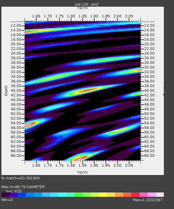
| Estimated Moho Depth: |
69.75 km |
| Estimated Crust Vp/Vs: |
1.83 |
| Assumed Crust Vp: |
6.566 km/s |
| Estimated Crust Vs: |
3.598 km/s |
| Estimated Crust Poisson's Ratio: |
0.29 |
|
| Radial Match: |
83.391884 % |
| Radial Bump: |
400 |
| Transverse Match: |
52.76365 % |
| Transverse Bump: |
400 |
| SOD ConfigId: |
30536071 |
| Insert Time: |
2023-08-02 00:58:39.409 +0000 |
| GWidth: |
2.5 |
| Max Bumps: |
400 |
| Tol: |
0.001 |
|

Signal To Noise
| Channel | StoN | STA | LTA |
| UW:CDF: :HHZ:20230719T00:29:36.480002Z | 5.1379895 | 2.7529592E-7 | 5.358048E-8 |
| UW:CDF: :HHN:20230719T00:29:36.480002Z | 0.9086363 | 1.2854491E-7 | 1.4147014E-7 |
| UW:CDF: :HHE:20230719T00:29:36.480002Z | 1.6080823 | 2.4864002E-7 | 1.5461896E-7 |
| Arrivals |
| Ps | 9.4 SECOND |
| PpPs | 28 SECOND |
| PsPs/PpSs | 37 SECOND |


