You are here: Home > Network List > UW - Pacific Northwest Regional Seismic Network Stations List
> Station HOPR Tall Timber Retreat WA > Earthquake Result Viewer
HOPR Tall Timber Retreat WA - Earthquake Result Viewer
| Earthquake location: |
Off Coast Of Central America |
| Earthquake latitude/longitude: |
12.8/-88.1 |
| Earthquake time(UTC): |
2023/07/19 (200) 00:22:07 GMT |
| Earthquake Depth: |
70 km |
| Earthquake Magnitude: |
6.5 mww |
| Earthquake Catalog/Contributor: |
NEIC PDE/us |
|
| Network: |
UW Pacific Northwest Regional Seismic Network |
| Station: |
HOPR Tall Timber Retreat WA |
| Lat/Lon: |
47.92 N/120.89 W |
| Elevation: |
597 m |
|
| Distance: |
44.4 deg |
| Az: |
328.633 deg |
| Baz: |
130.988 deg |
| Ray Param: |
0.071754284 |
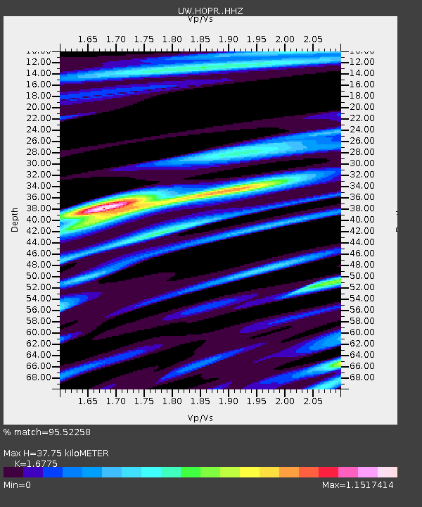
| Estimated Moho Depth: |
37.75 km |
| Estimated Crust Vp/Vs: |
1.68 |
| Assumed Crust Vp: |
6.597 km/s |
| Estimated Crust Vs: |
3.933 km/s |
| Estimated Crust Poisson's Ratio: |
0.22 |
|
| Radial Match: |
95.52258 % |
| Radial Bump: |
400 |
| Transverse Match: |
85.91451 % |
| Transverse Bump: |
400 |
| SOD ConfigId: |
30536071 |
| Insert Time: |
2023-08-02 00:59:40.175 +0000 |
| GWidth: |
2.5 |
| Max Bumps: |
400 |
| Tol: |
0.001 |
|

Signal To Noise
| Channel | StoN | STA | LTA |
| UW:HOPR: :HHZ:20230719T00:29:40.819998Z | 12.047774 | 8.4502017E-7 | 7.013911E-8 |
| UW:HOPR: :HHN:20230719T00:29:40.819998Z | 4.35527 | 4.1514608E-7 | 9.53204E-8 |
| UW:HOPR: :HHE:20230719T00:29:40.819998Z | 6.3253636 | 6.1643E-7 | 9.7453686E-8 |
| Arrivals |
| Ps | 4.2 SECOND |
| PpPs | 14 SECOND |
| PsPs/PpSs | 18 SECOND |


