You are here: Home > Network List > UW - Pacific Northwest Regional Seismic Network Stations List
> Station VFP Flag Point, OR, USA > Earthquake Result Viewer
VFP Flag Point, OR, USA - Earthquake Result Viewer
| Earthquake location: |
Off Coast Of Central America |
| Earthquake latitude/longitude: |
12.8/-88.1 |
| Earthquake time(UTC): |
2023/07/19 (200) 00:22:07 GMT |
| Earthquake Depth: |
70 km |
| Earthquake Magnitude: |
6.5 mww |
| Earthquake Catalog/Contributor: |
NEIC PDE/us |
|
| Network: |
UW Pacific Northwest Regional Seismic Network |
| Station: |
VFP Flag Point, OR, USA |
| Lat/Lon: |
45.32 N/121.47 W |
| Elevation: |
1722 m |
|
| Distance: |
43.0 deg |
| Az: |
325.363 deg |
| Baz: |
128.208 deg |
| Ray Param: |
0.07260225 |
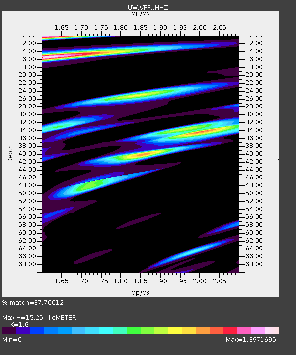
| Estimated Moho Depth: |
15.25 km |
| Estimated Crust Vp/Vs: |
1.60 |
| Assumed Crust Vp: |
6.597 km/s |
| Estimated Crust Vs: |
4.123 km/s |
| Estimated Crust Poisson's Ratio: |
0.18 |
|
| Radial Match: |
87.70012 % |
| Radial Bump: |
400 |
| Transverse Match: |
78.16975 % |
| Transverse Bump: |
400 |
| SOD ConfigId: |
30536071 |
| Insert Time: |
2023-08-02 01:02:12.736 +0000 |
| GWidth: |
2.5 |
| Max Bumps: |
400 |
| Tol: |
0.001 |
|

Signal To Noise
| Channel | StoN | STA | LTA |
| UW:VFP: :HHZ:20230719T00:29:29.939993Z | 6.035501 | 6.848784E-7 | 1.1347498E-7 |
| UW:VFP: :HHN:20230719T00:29:29.939993Z | 2.706594 | 4.4744198E-7 | 1.6531553E-7 |
| UW:VFP: :HHE:20230719T00:29:29.939993Z | 2.6926086 | 4.4717044E-7 | 1.6607332E-7 |
| Arrivals |
| Ps | 1.5 SECOND |
| PpPs | 5.6 SECOND |
| PsPs/PpSs | 7.1 SECOND |


