You are here: Home > Network List > TA - USArray Transportable Network (new EarthScope stations) Stations List
> Station J04D Umpqua National Forest, Toketee, OR, USA > Earthquake Result Viewer
J04D Umpqua National Forest, Toketee, OR, USA - Earthquake Result Viewer
| Earthquake location: |
Solomon Islands |
| Earthquake latitude/longitude: |
-10.6/161.4 |
| Earthquake time(UTC): |
2010/06/26 (177) 05:30:19 GMT |
| Earthquake Depth: |
35 km |
| Earthquake Magnitude: |
6.4 MB, 6.8 MS, 6.7 MW, 6.6 MW |
| Earthquake Catalog/Contributor: |
WHDF/NEIC |
|
| Network: |
TA USArray Transportable Network (new EarthScope stations) |
| Station: |
J04D Umpqua National Forest, Toketee, OR, USA |
| Lat/Lon: |
43.24 N/122.11 W |
| Elevation: |
1948 m |
|
| Distance: |
87.5 deg |
| Az: |
45.323 deg |
| Baz: |
253.054 deg |
| Ray Param: |
0.043224294 |
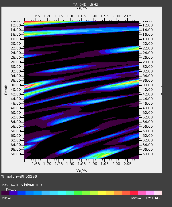
| Estimated Moho Depth: |
38.5 km |
| Estimated Crust Vp/Vs: |
1.60 |
| Assumed Crust Vp: |
6.522 km/s |
| Estimated Crust Vs: |
4.076 km/s |
| Estimated Crust Poisson's Ratio: |
0.18 |
|
| Radial Match: |
89.00296 % |
| Radial Bump: |
400 |
| Transverse Match: |
84.21159 % |
| Transverse Bump: |
400 |
| SOD ConfigId: |
318645 |
| Insert Time: |
2010-11-29 19:28:40.386 +0000 |
| GWidth: |
2.5 |
| Max Bumps: |
400 |
| Tol: |
0.001 |
|

Signal To Noise
| Channel | StoN | STA | LTA |
| TA:J04D: :BHZ:20100626T05:42:32.450022Z | 14.064383 | 1.5423007E-6 | 1.09660036E-7 |
| TA:J04D: :BHN:20100626T05:42:32.450022Z | 1.3367527 | 2.5368254E-7 | 1.8977525E-7 |
| TA:J04D: :BHE:20100626T05:42:32.450022Z | 2.514534 | 5.1159094E-7 | 2.0345358E-7 |
| Arrivals |
| Ps | 3.6 SECOND |
| PpPs | 15 SECOND |
| PsPs/PpSs | 19 SECOND |


