You are here: Home > Network List > TA - USArray Transportable Network (new EarthScope stations) Stations List
> Station K04D Chiloquin, OR, USA > Earthquake Result Viewer
K04D Chiloquin, OR, USA - Earthquake Result Viewer
| Earthquake location: |
Solomon Islands |
| Earthquake latitude/longitude: |
-10.6/161.4 |
| Earthquake time(UTC): |
2010/06/26 (177) 05:30:19 GMT |
| Earthquake Depth: |
35 km |
| Earthquake Magnitude: |
6.4 MB, 6.8 MS, 6.7 MW, 6.6 MW |
| Earthquake Catalog/Contributor: |
WHDF/NEIC |
|
| Network: |
TA USArray Transportable Network (new EarthScope stations) |
| Station: |
K04D Chiloquin, OR, USA |
| Lat/Lon: |
42.62 N/121.75 W |
| Elevation: |
1315 m |
|
| Distance: |
87.6 deg |
| Az: |
45.989 deg |
| Baz: |
253.324 deg |
| Ray Param: |
0.043170754 |
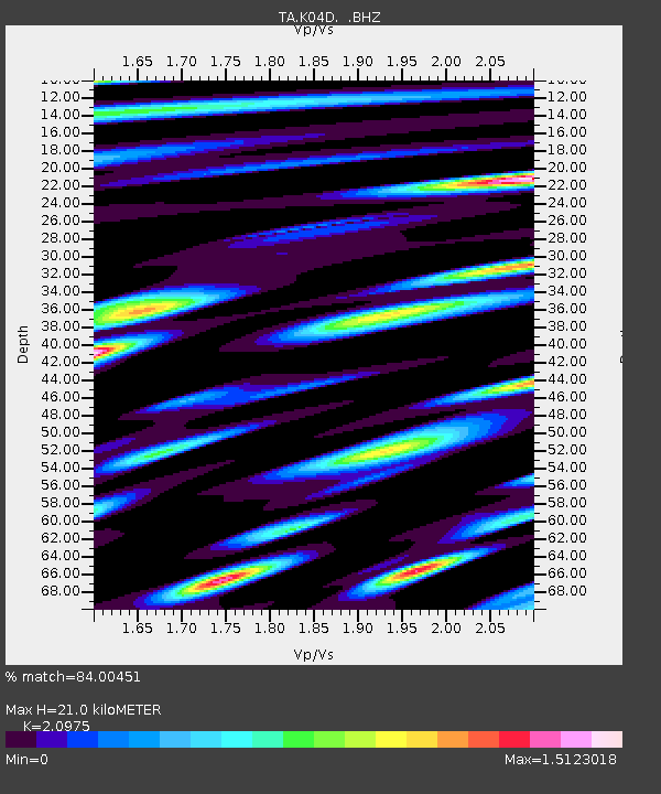
| Estimated Moho Depth: |
21.0 km |
| Estimated Crust Vp/Vs: |
2.10 |
| Assumed Crust Vp: |
6.597 km/s |
| Estimated Crust Vs: |
3.145 km/s |
| Estimated Crust Poisson's Ratio: |
0.35 |
|
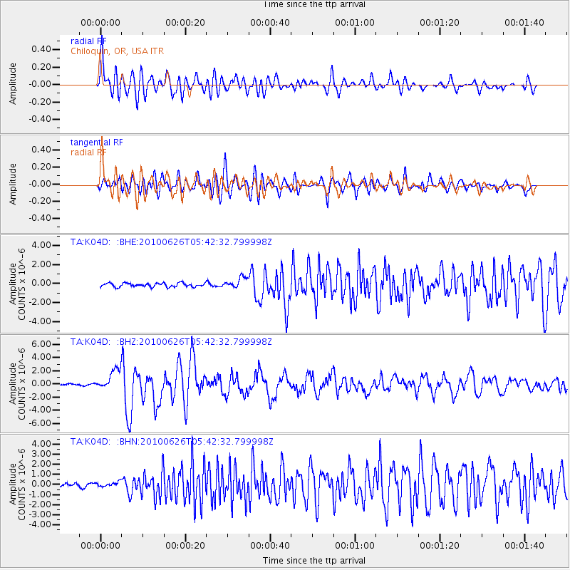
| Radial Match: |
84.00451 % |
| Radial Bump: |
400 |
| Transverse Match: |
82.630356 % |
| Transverse Bump: |
400 |
| SOD ConfigId: |
318645 |
| Insert Time: |
2010-11-29 19:28:51.603 +0000 |
| GWidth: |
2.5 |
| Max Bumps: |
400 |
| Tol: |
0.001 |
|
Signal To Noise
| Channel | StoN | STA | LTA |
| TA:K04D: :BHZ:20100626T05:42:32.799998Z | 14.485251 | 1.5923455E-6 | 1.0992874E-7 |
| TA:K04D: :BHN:20100626T05:42:32.799998Z | 1.7120464 | 2.3727847E-7 | 1.3859348E-7 |
| TA:K04D: :BHE:20100626T05:42:32.799998Z | 2.9255893 | 5.6648526E-7 | 1.9363115E-7 |
| Arrivals |
| Ps | 3.6 SECOND |
| PpPs | 9.7 SECOND |
| PsPs/PpSs | 13 SECOND |


