You are here: Home > Network List > TA - USArray Transportable Network (new EarthScope stations) Stations List
> Station G05D Wamic, OR, USA > Earthquake Result Viewer
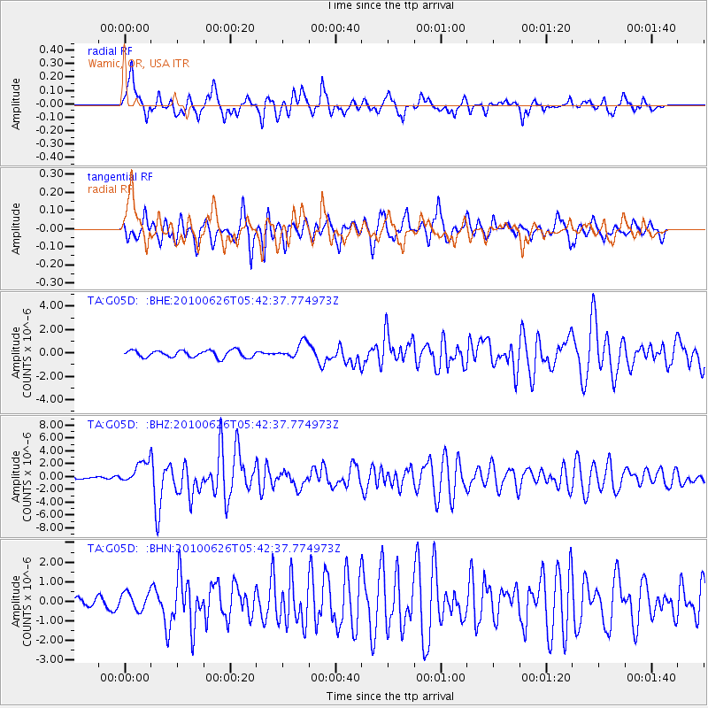
G05D Wamic, OR, USA - Earthquake Result Viewer
*The percent match for this event was below the threshold and hence no stack was calculated.
| Earthquake location: |
Solomon Islands |
| Earthquake latitude/longitude: |
-10.6/161.4 |
| Earthquake time(UTC): |
2010/06/26 (177) 05:30:19 GMT |
| Earthquake Depth: |
35 km |
| Earthquake Magnitude: |
6.4 MB, 6.8 MS, 6.7 MW, 6.6 MW |
| Earthquake Catalog/Contributor: |
WHDF/NEIC |
|
| Network: |
TA USArray Transportable Network (new EarthScope stations) |
| Station: |
G05D Wamic, OR, USA |
| Lat/Lon: |
45.24 N/121.32 W |
| Elevation: |
592 m |
|
| Distance: |
88.6 deg |
| Az: |
43.569 deg |
| Baz: |
253.547 deg |
| Ray Param: |
$rayparam |
*The percent match for this event was below the threshold and hence was not used in the summary stack. |
|
| Radial Match: |
80.18049 % |
| Radial Bump: |
400 |
| Transverse Match: |
76.06375 % |
| Transverse Bump: |
400 |
| SOD ConfigId: |
318645 |
| Insert Time: |
2010-11-29 19:29:05.284 +0000 |
| GWidth: |
2.5 |
| Max Bumps: |
400 |
| Tol: |
0.001 |
|
Signal To Noise
| Channel | StoN | STA | LTA |
| TA:G05D: :BHZ:20100626T05:42:37.774973Z | 10.294573 | 1.7889969E-6 | 1.7378058E-7 |
| TA:G05D: :BHN:20100626T05:42:37.774973Z | 1.9529405 | 4.5926313E-7 | 2.3516495E-7 |
| TA:G05D: :BHE:20100626T05:42:37.774973Z | 2.3469663 | 6.9991745E-7 | 2.9822218E-7 |
| Arrivals |
| Ps | |
| PpPs | |
| PsPs/PpSs | |


