You are here: Home > Network List > TA - USArray Transportable Network (new EarthScope stations) Stations List
> Station I03D Drain, OR, USA > Earthquake Result Viewer
I03D Drain, OR, USA - Earthquake Result Viewer

| Earthquake location: |
Solomon Islands |
| Earthquake latitude/longitude: |
-10.6/161.4 |
| Earthquake time(UTC): |
2010/06/26 (177) 05:30:19 GMT |
| Earthquake Depth: |
35 km |
| Earthquake Magnitude: |
6.4 MB, 6.8 MS, 6.7 MW, 6.6 MW |
| Earthquake Catalog/Contributor: |
WHDF/NEIC |
|
| Network: |
TA USArray Transportable Network (new EarthScope stations) |
| Station: |
I03D Drain, OR, USA |
| Lat/Lon: |
43.70 N/123.35 W |
| Elevation: |
140 m |
|
| Distance: |
86.8 deg |
| Az: |
44.617 deg |
| Baz: |
252.17 deg |
| Ray Param: |
0.043746624 |
| Estimated Moho Depth: |
39.0 km |
| Estimated Crust Vp/Vs: |
1.89 |
| Assumed Crust Vp: |
6.522 km/s |
| Estimated Crust Vs: |
3.441 km/s |
| Estimated Crust Poisson's Ratio: |
0.31 |
|
| Radial Match: |
93.16106 % |
| Radial Bump: |
400 |
| Transverse Match: |
84.31755 % |
| Transverse Bump: |
400 |
| SOD ConfigId: |
318645 |
| Insert Time: |
2010-11-29 19:29:17.128 +0000 |
| GWidth: |
2.5 |
| Max Bumps: |
400 |
| Tol: |
0.001 |
|
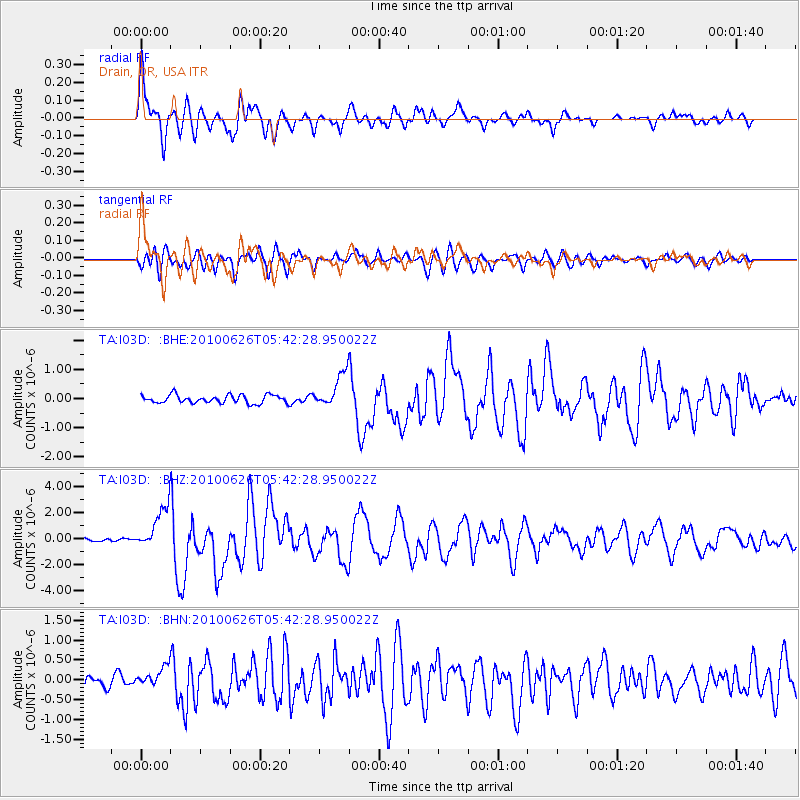
Signal To Noise
| Channel | StoN | STA | LTA |
| TA:I03D: :BHZ:20100626T05:42:28.950022Z | 15.647032 | 1.6376769E-6 | 1.04663734E-7 |
| TA:I03D: :BHN:20100626T05:42:28.950022Z | 2.124668 | 2.410071E-7 | 1.13432826E-7 |
| TA:I03D: :BHE:20100626T05:42:28.950022Z | 4.230415 | 5.857253E-7 | 1.3845575E-7 |
| Arrivals |
| Ps | 5.5 SECOND |
| PpPs | 17 SECOND |
| PsPs/PpSs | 22 SECOND |


