You are here: Home > Network List > AV - Alaska Volcano Observatory Stations List
> Station ILNE Iliamna Northeast, Iliamna, Alaska > Earthquake Result Viewer
ILNE Iliamna Northeast, Iliamna, Alaska - Earthquake Result Viewer
| Earthquake location: |
Tonga Islands Region |
| Earthquake latitude/longitude: |
-22.6/-175.0 |
| Earthquake time(UTC): |
2023/07/21 (202) 19:01:43 GMT |
| Earthquake Depth: |
11 km |
| Earthquake Magnitude: |
5.5 Mww |
| Earthquake Catalog/Contributor: |
NEIC PDE/us |
|
| Network: |
AV Alaska Volcano Observatory |
| Station: |
ILNE Iliamna Northeast, Iliamna, Alaska |
| Lat/Lon: |
60.06 N/153.06 W |
| Elevation: |
1614 m |
|
| Distance: |
84.3 deg |
| Az: |
10.876 deg |
| Baz: |
200.332 deg |
| Ray Param: |
0.04555268 |
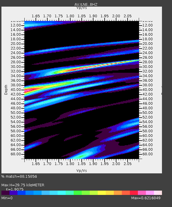
| Estimated Moho Depth: |
29.75 km |
| Estimated Crust Vp/Vs: |
1.91 |
| Assumed Crust Vp: |
6.566 km/s |
| Estimated Crust Vs: |
3.442 km/s |
| Estimated Crust Poisson's Ratio: |
0.31 |
|
| Radial Match: |
88.15856 % |
| Radial Bump: |
400 |
| Transverse Match: |
67.26301 % |
| Transverse Bump: |
400 |
| SOD ConfigId: |
30536071 |
| Insert Time: |
2023-08-04 19:09:20.079 +0000 |
| GWidth: |
2.5 |
| Max Bumps: |
400 |
| Tol: |
0.001 |
|

Signal To Noise
| Channel | StoN | STA | LTA |
| AV:ILNE: :BHZ:20230721T19:13:44.139994Z | 7.024176 | 2.6051302E-7 | 3.708805E-8 |
| AV:ILNE: :BHN:20230721T19:13:44.139994Z | 2.835646 | 1.372707E-7 | 4.840897E-8 |
| AV:ILNE: :BHE:20230721T19:13:44.139994Z | 2.0270426 | 1.1515501E-7 | 5.680937E-8 |
| Arrivals |
| Ps | 4.2 SECOND |
| PpPs | 13 SECOND |
| PsPs/PpSs | 17 SECOND |


