You are here: Home > Network List > AV - Alaska Volcano Observatory Stations List
> Station Q20K Shuyak Island, AK, USA > Earthquake Result Viewer
Q20K Shuyak Island, AK, USA - Earthquake Result Viewer
| Earthquake location: |
Tonga Islands Region |
| Earthquake latitude/longitude: |
-22.6/-175.0 |
| Earthquake time(UTC): |
2023/07/21 (202) 19:01:43 GMT |
| Earthquake Depth: |
11 km |
| Earthquake Magnitude: |
5.5 Mww |
| Earthquake Catalog/Contributor: |
NEIC PDE/us |
|
| Network: |
AV Alaska Volcano Observatory |
| Station: |
Q20K Shuyak Island, AK, USA |
| Lat/Lon: |
58.61 N/152.39 W |
| Elevation: |
180 m |
|
| Distance: |
83.1 deg |
| Az: |
11.714 deg |
| Baz: |
200.999 deg |
| Ray Param: |
0.046425827 |
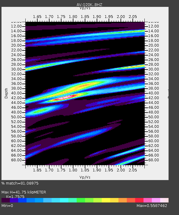
| Estimated Moho Depth: |
41.75 km |
| Estimated Crust Vp/Vs: |
1.76 |
| Assumed Crust Vp: |
5.989 km/s |
| Estimated Crust Vs: |
3.408 km/s |
| Estimated Crust Poisson's Ratio: |
0.26 |
|
| Radial Match: |
81.06975 % |
| Radial Bump: |
400 |
| Transverse Match: |
61.532017 % |
| Transverse Bump: |
400 |
| SOD ConfigId: |
30536071 |
| Insert Time: |
2023-08-04 19:10:40.709 +0000 |
| GWidth: |
2.5 |
| Max Bumps: |
400 |
| Tol: |
0.001 |
|

Signal To Noise
| Channel | StoN | STA | LTA |
| AV:Q20K: :BHZ:20230721T19:13:37.824992Z | 4.5921845 | 3.4368966E-7 | 7.4842305E-8 |
| AV:Q20K: :BHN:20230721T19:13:37.824992Z | 1.7412102 | 1.2136962E-7 | 6.970417E-8 |
| AV:Q20K: :BHE:20230721T19:13:37.824992Z | 1.2027125 | 8.410194E-8 | 6.992689E-8 |
| Arrivals |
| Ps | 5.4 SECOND |
| PpPs | 19 SECOND |
| PsPs/PpSs | 24 SECOND |


