You are here: Home > Network List > AV - Alaska Volcano Observatory Stations List
> Station SPCP Crater Peak Broadband, Mount Spurr, Alaska > Earthquake Result Viewer
SPCP Crater Peak Broadband, Mount Spurr, Alaska - Earthquake Result Viewer
| Earthquake location: |
Tonga Islands Region |
| Earthquake latitude/longitude: |
-22.6/-175.0 |
| Earthquake time(UTC): |
2023/07/21 (202) 19:01:43 GMT |
| Earthquake Depth: |
11 km |
| Earthquake Magnitude: |
5.5 Mww |
| Earthquake Catalog/Contributor: |
NEIC PDE/us |
|
| Network: |
AV Alaska Volcano Observatory |
| Station: |
SPCP Crater Peak Broadband, Mount Spurr, Alaska |
| Lat/Lon: |
61.27 N/152.15 W |
| Elevation: |
1616 m |
|
| Distance: |
85.6 deg |
| Az: |
10.865 deg |
| Baz: |
201.122 deg |
| Ray Param: |
0.044625036 |
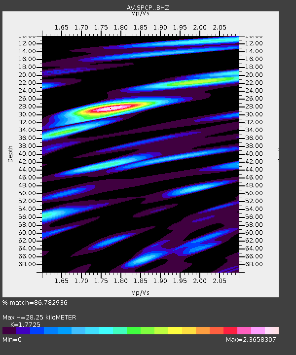
| Estimated Moho Depth: |
28.25 km |
| Estimated Crust Vp/Vs: |
1.77 |
| Assumed Crust Vp: |
6.566 km/s |
| Estimated Crust Vs: |
3.704 km/s |
| Estimated Crust Poisson's Ratio: |
0.27 |
|
| Radial Match: |
86.782936 % |
| Radial Bump: |
400 |
| Transverse Match: |
77.528984 % |
| Transverse Bump: |
400 |
| SOD ConfigId: |
30536071 |
| Insert Time: |
2023-08-04 19:11:06.704 +0000 |
| GWidth: |
2.5 |
| Max Bumps: |
400 |
| Tol: |
0.001 |
|

Signal To Noise
| Channel | StoN | STA | LTA |
| AV:SPCP: :BHZ:20230721T19:13:50.587992Z | 7.3317943 | 4.1628363E-7 | 5.6777864E-8 |
| AV:SPCP: :BHN:20230721T19:13:50.587992Z | 3.063757 | 1.9497438E-7 | 6.3638986E-8 |
| AV:SPCP: :BHE:20230721T19:13:50.587992Z | 1.4295316 | 8.3778666E-8 | 5.860568E-8 |
| Arrivals |
| Ps | 3.4 SECOND |
| PpPs | 12 SECOND |
| PsPs/PpSs | 15 SECOND |


