You are here: Home > Network List > GS - US Geological Survey Networks Stations List
> Station ASA5 ASA5 > Earthquake Result Viewer
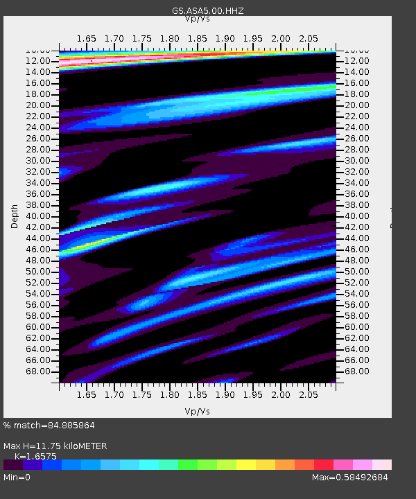
ASA5 ASA5 - Earthquake Result Viewer
| Earthquake location: |
Tonga Islands Region |
| Earthquake latitude/longitude: |
-22.6/-175.0 |
| Earthquake time(UTC): |
2023/07/21 (202) 19:01:43 GMT |
| Earthquake Depth: |
11 km |
| Earthquake Magnitude: |
5.5 Mww |
| Earthquake Catalog/Contributor: |
NEIC PDE/us |
|
| Network: |
GS US Geological Survey Networks |
| Station: |
ASA5 ASA5 |
| Lat/Lon: |
34.94 N/106.46 W |
| Elevation: |
1835 m |
|
| Distance: |
86.6 deg |
| Az: |
50.007 deg |
| Baz: |
239.49 deg |
| Ray Param: |
0.04391665 |
| Estimated Moho Depth: |
11.75 km |
| Estimated Crust Vp/Vs: |
1.66 |
| Assumed Crust Vp: |
6.502 km/s |
| Estimated Crust Vs: |
3.922 km/s |
| Estimated Crust Poisson's Ratio: |
0.21 |
|
| Radial Match: |
84.885864 % |
| Radial Bump: |
366 |
| Transverse Match: |
70.81087 % |
| Transverse Bump: |
353 |
| SOD ConfigId: |
30536071 |
| Insert Time: |
2023-08-04 19:18:04.528 +0000 |
| GWidth: |
2.5 |
| Max Bumps: |
400 |
| Tol: |
0.001 |
|

Signal To Noise
| Channel | StoN | STA | LTA |
| GS:ASA5:00:HHZ:20230721T19:13:55.468974Z | 3.4934146 | 1.16483264E-7 | 3.334367E-8 |
| GS:ASA5:00:HH1:20230721T19:13:55.468974Z | 1.3116081 | 3.3986822E-8 | 2.5912332E-8 |
| GS:ASA5:00:HH2:20230721T19:13:55.468974Z | 1.2272573 | 3.413682E-8 | 2.7815537E-8 |
| Arrivals |
| Ps | 1.2 SECOND |
| PpPs | 4.7 SECOND |
| PsPs/PpSs | 5.9 SECOND |


