You are here: Home > Network List > IU - Global Seismograph Network (GSN - IRIS/USGS) Stations List
> Station RSSD Black Hills, South Dakota, USA > Earthquake Result Viewer
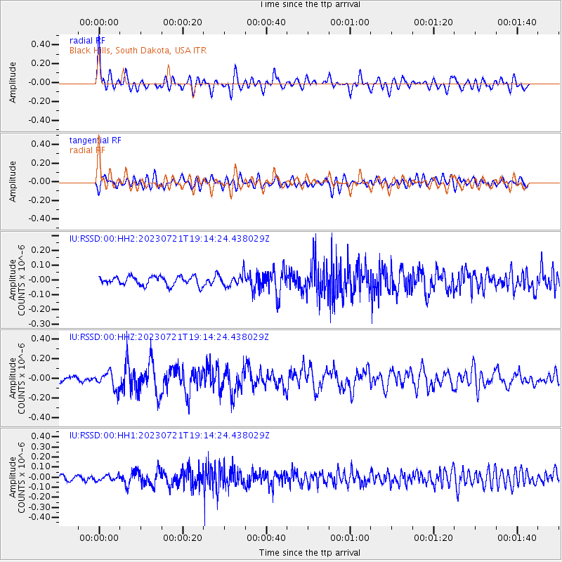
RSSD Black Hills, South Dakota, USA - Earthquake Result Viewer
*The percent match for this event was below the threshold and hence no stack was calculated.
| Earthquake location: |
Tonga Islands Region |
| Earthquake latitude/longitude: |
-22.6/-175.0 |
| Earthquake time(UTC): |
2023/07/21 (202) 19:01:43 GMT |
| Earthquake Depth: |
11 km |
| Earthquake Magnitude: |
5.5 Mww |
| Earthquake Catalog/Contributor: |
NEIC PDE/us |
|
| Network: |
IU Global Seismograph Network (GSN - IRIS/USGS) |
| Station: |
RSSD Black Hills, South Dakota, USA |
| Lat/Lon: |
44.12 N/104.04 W |
| Elevation: |
2090 m |
|
| Distance: |
92.8 deg |
| Az: |
42.985 deg |
| Baz: |
240.997 deg |
| Ray Param: |
$rayparam |
*The percent match for this event was below the threshold and hence was not used in the summary stack. |
|
| Radial Match: |
67.40616 % |
| Radial Bump: |
400 |
| Transverse Match: |
55.745426 % |
| Transverse Bump: |
400 |
| SOD ConfigId: |
30536071 |
| Insert Time: |
2023-08-04 19:19:15.004 +0000 |
| GWidth: |
2.5 |
| Max Bumps: |
400 |
| Tol: |
0.001 |
|
Signal To Noise
| Channel | StoN | STA | LTA |
| IU:RSSD:00:HHZ:20230721T19:14:24.438029Z | 2.7157464 | 9.124181E-8 | 3.359732E-8 |
| IU:RSSD:00:HH1:20230721T19:14:24.438029Z | 0.7995052 | 2.512888E-8 | 3.143054E-8 |
| IU:RSSD:00:HH2:20230721T19:14:24.438029Z | 1.3183781 | 3.9212345E-8 | 2.9742866E-8 |
| Arrivals |
| Ps | |
| PpPs | |
| PsPs/PpSs | |


