You are here: Home > Network List > US - United States National Seismic Network Stations List
> Station EGMT Eagleton, Montana, USA > Earthquake Result Viewer
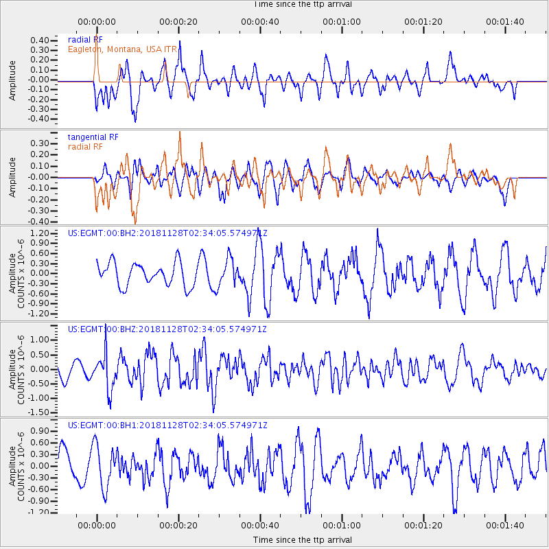
EGMT Eagleton, Montana, USA - Earthquake Result Viewer
*The percent match for this event was below the threshold and hence no stack was calculated.
| Earthquake location: |
Hokkaido, Japan Region |
| Earthquake latitude/longitude: |
41.4/143.3 |
| Earthquake time(UTC): |
2018/11/28 (332) 02:23:24 GMT |
| Earthquake Depth: |
10 km |
| Earthquake Magnitude: |
5.5 Mww |
| Earthquake Catalog/Contributor: |
NEIC PDE/us |
|
| Network: |
US United States National Seismic Network |
| Station: |
EGMT Eagleton, Montana, USA |
| Lat/Lon: |
48.02 N/109.75 W |
| Elevation: |
1055 m |
|
| Distance: |
70.1 deg |
| Az: |
43.061 deg |
| Baz: |
310.026 deg |
| Ray Param: |
$rayparam |
*The percent match for this event was below the threshold and hence was not used in the summary stack. |
|
| Radial Match: |
72.912674 % |
| Radial Bump: |
400 |
| Transverse Match: |
52.002735 % |
| Transverse Bump: |
389 |
| SOD ConfigId: |
3165032 |
| Insert Time: |
2018-12-12 02:37:25.411 +0000 |
| GWidth: |
2.5 |
| Max Bumps: |
400 |
| Tol: |
0.001 |
|
Signal To Noise
| Channel | StoN | STA | LTA |
| US:EGMT:00:BHZ:20181128T02:34:05.574971Z | 1.4501883 | 6.2719835E-7 | 4.3249446E-7 |
| US:EGMT:00:BH1:20181128T02:34:05.574971Z | 1.3150231 | 5.5675747E-7 | 4.233823E-7 |
| US:EGMT:00:BH2:20181128T02:34:05.574971Z | 1.2254103 | 4.1344444E-7 | 3.3739266E-7 |
| Arrivals |
| Ps | |
| PpPs | |
| PsPs/PpSs | |


