You are here: Home > Network List > US - United States National Seismic Network Stations List
> Station DUG Dugway, Tooele County, Utah, USA > Earthquake Result Viewer
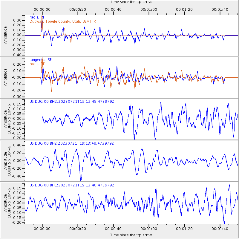
DUG Dugway, Tooele County, Utah, USA - Earthquake Result Viewer
*The percent match for this event was below the threshold and hence no stack was calculated.
| Earthquake location: |
Tonga Islands Region |
| Earthquake latitude/longitude: |
-22.6/-175.0 |
| Earthquake time(UTC): |
2023/07/21 (202) 19:01:43 GMT |
| Earthquake Depth: |
11 km |
| Earthquake Magnitude: |
5.5 Mww |
| Earthquake Catalog/Contributor: |
NEIC PDE/us |
|
| Network: |
US United States National Seismic Network |
| Station: |
DUG Dugway, Tooele County, Utah, USA |
| Lat/Lon: |
40.19 N/112.81 W |
| Elevation: |
1477 m |
|
| Distance: |
85.2 deg |
| Az: |
42.855 deg |
| Baz: |
235.116 deg |
| Ray Param: |
$rayparam |
*The percent match for this event was below the threshold and hence was not used in the summary stack. |
|
| Radial Match: |
79.43401 % |
| Radial Bump: |
400 |
| Transverse Match: |
80.69259 % |
| Transverse Bump: |
400 |
| SOD ConfigId: |
30536071 |
| Insert Time: |
2023-08-04 19:28:00.215 +0000 |
| GWidth: |
2.5 |
| Max Bumps: |
400 |
| Tol: |
0.001 |
|
Signal To Noise
| Channel | StoN | STA | LTA |
| US:DUG:00:BHZ:20230721T19:13:48.473979Z | 2.6841214 | 1.2051265E-7 | 4.489836E-8 |
| US:DUG:00:BH1:20230721T19:13:48.473979Z | 0.9706849 | 3.0926604E-8 | 3.1860598E-8 |
| US:DUG:00:BH2:20230721T19:13:48.473979Z | 1.4274462 | 4.272758E-8 | 2.993288E-8 |
| Arrivals |
| Ps | |
| PpPs | |
| PsPs/PpSs | |


