You are here: Home > Network List > US - United States National Seismic Network Stations List
> Station WMOK Wichita Mountains, Oklahoma, USA > Earthquake Result Viewer
WMOK Wichita Mountains, Oklahoma, USA - Earthquake Result Viewer
*The percent match for this event was below the threshold and hence no stack was calculated.
| Earthquake location: |
Hokkaido, Japan Region |
| Earthquake latitude/longitude: |
41.4/143.3 |
| Earthquake time(UTC): |
2018/11/28 (332) 02:23:24 GMT |
| Earthquake Depth: |
10 km |
| Earthquake Magnitude: |
5.5 Mww |
| Earthquake Catalog/Contributor: |
NEIC PDE/us |
|
| Network: |
US United States National Seismic Network |
| Station: |
WMOK Wichita Mountains, Oklahoma, USA |
| Lat/Lon: |
34.74 N/98.78 W |
| Elevation: |
486 m |
|
| Distance: |
85.3 deg |
| Az: |
46.885 deg |
| Baz: |
318.138 deg |
| Ray Param: |
$rayparam |
*The percent match for this event was below the threshold and hence was not used in the summary stack. |
|
| Radial Match: |
58.805748 % |
| Radial Bump: |
400 |
| Transverse Match: |
66.45679 % |
| Transverse Bump: |
400 |
| SOD ConfigId: |
3165032 |
| Insert Time: |
2018-12-12 02:37:53.759 +0000 |
| GWidth: |
2.5 |
| Max Bumps: |
400 |
| Tol: |
0.001 |
|
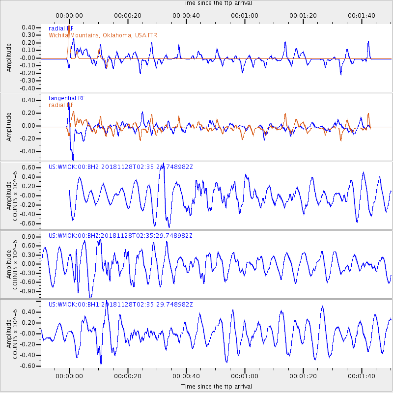
Signal To Noise
| Channel | StoN | STA | LTA |
| US:WMOK:00:BHZ:20181128T02:35:29.748982Z | 1.4400352 | 4.1756383E-7 | 2.899678E-7 |
| US:WMOK:00:BH1:20181128T02:35:29.748982Z | 0.74536705 | 2.1196477E-7 | 2.8437637E-7 |
| US:WMOK:00:BH2:20181128T02:35:29.748982Z | 2.6488605 | 5.2128786E-7 | 1.9679703E-7 |
| Arrivals |
| Ps | |
| PpPs | |
| PsPs/PpSs | |


