You are here: Home > Network List > UW - Pacific Northwest Regional Seismic Network Stations List
> Station SLF Sugar Loaf > Earthquake Result Viewer
SLF Sugar Loaf - Earthquake Result Viewer
| Earthquake location: |
Tonga Islands Region |
| Earthquake latitude/longitude: |
-22.6/-175.0 |
| Earthquake time(UTC): |
2023/07/21 (202) 19:01:43 GMT |
| Earthquake Depth: |
11 km |
| Earthquake Magnitude: |
5.5 Mww |
| Earthquake Catalog/Contributor: |
NEIC PDE/us |
|
| Network: |
UW Pacific Northwest Regional Seismic Network |
| Station: |
SLF Sugar Loaf |
| Lat/Lon: |
47.76 N/120.53 W |
| Elevation: |
1739 m |
|
| Distance: |
85.5 deg |
| Az: |
33.444 deg |
| Baz: |
228.992 deg |
| Ray Param: |
0.044754878 |
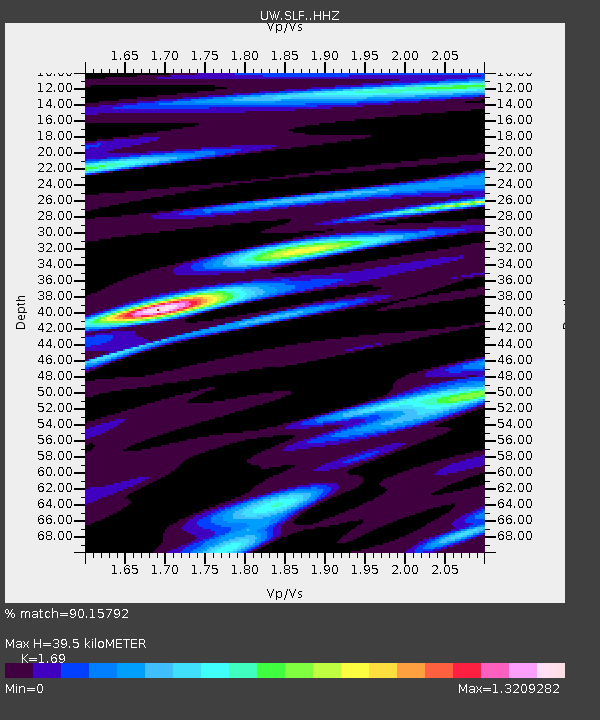
| Estimated Moho Depth: |
39.5 km |
| Estimated Crust Vp/Vs: |
1.69 |
| Assumed Crust Vp: |
6.597 km/s |
| Estimated Crust Vs: |
3.904 km/s |
| Estimated Crust Poisson's Ratio: |
0.23 |
|
| Radial Match: |
90.15792 % |
| Radial Bump: |
400 |
| Transverse Match: |
76.900795 % |
| Transverse Bump: |
400 |
| SOD ConfigId: |
30536071 |
| Insert Time: |
2023-08-04 19:30:58.835 +0000 |
| GWidth: |
2.5 |
| Max Bumps: |
400 |
| Tol: |
0.001 |
|

Signal To Noise
| Channel | StoN | STA | LTA |
| UW:SLF: :HHZ:20230721T19:13:49.689982Z | 3.0605986 | 2.0664994E-7 | 6.751945E-8 |
| UW:SLF: :HHN:20230721T19:13:49.689982Z | 1.6710559 | 9.008375E-8 | 5.390828E-8 |
| UW:SLF: :HHE:20230721T19:13:49.689982Z | 1.6966182 | 7.64396E-8 | 4.5054097E-8 |
| Arrivals |
| Ps | 4.2 SECOND |
| PpPs | 16 SECOND |
| PsPs/PpSs | 20 SECOND |


