You are here: Home > Network List > UW - Pacific Northwest Regional Seismic Network Stations List
> Station TOUT Weyerhaeuser Mt St Helens Tree Farm, Cowlitz County, WA, USA > Earthquake Result Viewer
TOUT Weyerhaeuser Mt St Helens Tree Farm, Cowlitz County, WA, USA - Earthquake Result Viewer
| Earthquake location: |
Tonga Islands Region |
| Earthquake latitude/longitude: |
-22.6/-175.0 |
| Earthquake time(UTC): |
2023/07/21 (202) 19:01:43 GMT |
| Earthquake Depth: |
11 km |
| Earthquake Magnitude: |
5.5 Mww |
| Earthquake Catalog/Contributor: |
NEIC PDE/us |
|
| Network: |
UW Pacific Northwest Regional Seismic Network |
| Station: |
TOUT Weyerhaeuser Mt St Helens Tree Farm, Cowlitz County, WA, USA |
| Lat/Lon: |
46.30 N/122.56 W |
| Elevation: |
822 m |
|
| Distance: |
83.4 deg |
| Az: |
33.606 deg |
| Baz: |
227.524 deg |
| Ray Param: |
0.04618699 |
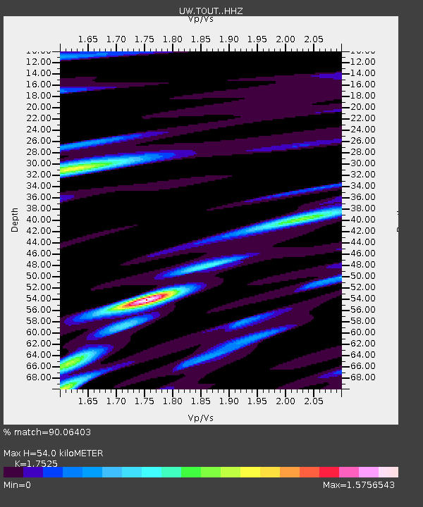
| Estimated Moho Depth: |
54.0 km |
| Estimated Crust Vp/Vs: |
1.75 |
| Assumed Crust Vp: |
6.566 km/s |
| Estimated Crust Vs: |
3.747 km/s |
| Estimated Crust Poisson's Ratio: |
0.26 |
|
| Radial Match: |
90.06403 % |
| Radial Bump: |
400 |
| Transverse Match: |
79.098755 % |
| Transverse Bump: |
400 |
| SOD ConfigId: |
30536071 |
| Insert Time: |
2023-08-04 19:31:39.646 +0000 |
| GWidth: |
2.5 |
| Max Bumps: |
400 |
| Tol: |
0.001 |
|

Signal To Noise
| Channel | StoN | STA | LTA |
| UW:TOUT: :HHZ:20230721T19:13:39.559977Z | 4.220731 | 1.809568E-7 | 4.287333E-8 |
| UW:TOUT: :HHN:20230721T19:13:39.559977Z | 1.1920036 | 5.7630093E-8 | 4.8347246E-8 |
| UW:TOUT: :HHE:20230721T19:13:39.559977Z | 1.4779749 | 9.677456E-8 | 6.547781E-8 |
| Arrivals |
| Ps | 6.4 SECOND |
| PpPs | 22 SECOND |
| PsPs/PpSs | 28 SECOND |


