You are here: Home > Network List > TA - USArray Transportable Network (new EarthScope stations) Stations List
> Station 334A Lometa, TX, USA > Earthquake Result Viewer
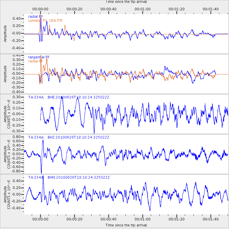
334A Lometa, TX, USA - Earthquake Result Viewer
*The percent match for this event was below the threshold and hence no stack was calculated.
| Earthquake location: |
Northern Chile |
| Earthquake latitude/longitude: |
-18.9/-69.2 |
| Earthquake time(UTC): |
2010/06/26 (177) 19:01:18 GMT |
| Earthquake Depth: |
104 km |
| Earthquake Magnitude: |
5.5 MB, 5.4 MW |
| Earthquake Catalog/Contributor: |
WHDF/NEIC |
|
| Network: |
TA USArray Transportable Network (new EarthScope stations) |
| Station: |
334A Lometa, TX, USA |
| Lat/Lon: |
31.33 N/98.24 W |
| Elevation: |
389 m |
|
| Distance: |
57.2 deg |
| Az: |
330.366 deg |
| Baz: |
146.84 deg |
| Ray Param: |
$rayparam |
*The percent match for this event was below the threshold and hence was not used in the summary stack. |
|
| Radial Match: |
48.0822 % |
| Radial Bump: |
400 |
| Transverse Match: |
47.99326 % |
| Transverse Bump: |
400 |
| SOD ConfigId: |
318645 |
| Insert Time: |
2010-11-29 19:38:08.997 +0000 |
| GWidth: |
2.5 |
| Max Bumps: |
400 |
| Tol: |
0.001 |
|
Signal To Noise
| Channel | StoN | STA | LTA |
| TA:334A: :BHZ:20100626T19:10:24.325022Z | 2.6599386 | 3.346453E-7 | 1.2580941E-7 |
| TA:334A: :BHN:20100626T19:10:24.325022Z | 2.159327 | 2.1048258E-7 | 9.747601E-8 |
| TA:334A: :BHE:20100626T19:10:24.325022Z | 0.81072277 | 1.16917384E-7 | 1.4421377E-7 |
| Arrivals |
| Ps | |
| PpPs | |
| PsPs/PpSs | |


