You are here: Home > Network List > WY - Yellowstone Wyoming Seismic Network Stations List
> Station YHH Holmes Hill, YNP, WY, USA > Earthquake Result Viewer
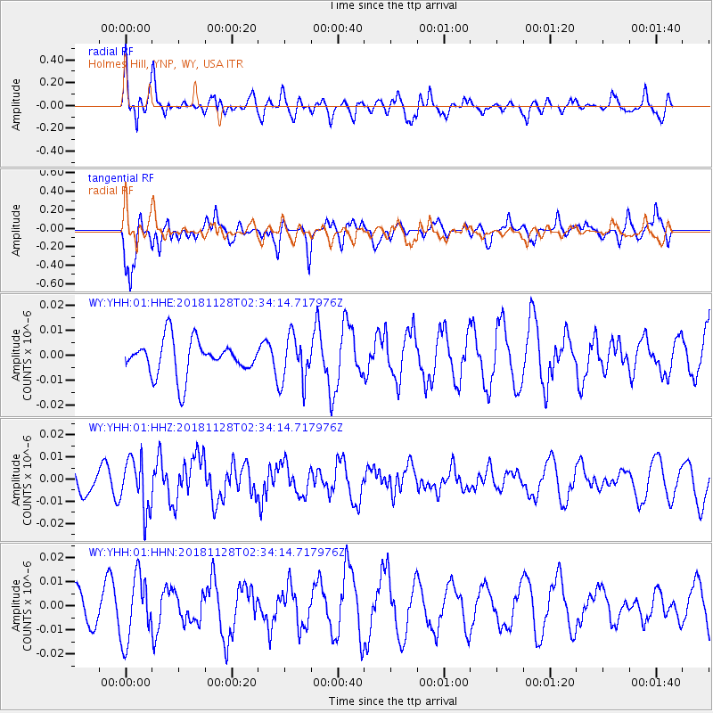
YHH Holmes Hill, YNP, WY, USA - Earthquake Result Viewer
*The percent match for this event was below the threshold and hence no stack was calculated.
| Earthquake location: |
Hokkaido, Japan Region |
| Earthquake latitude/longitude: |
41.4/143.3 |
| Earthquake time(UTC): |
2018/11/28 (332) 02:23:24 GMT |
| Earthquake Depth: |
10 km |
| Earthquake Magnitude: |
5.5 Mww |
| Earthquake Catalog/Contributor: |
NEIC PDE/us |
|
| Network: |
WY Yellowstone Wyoming Seismic Network |
| Station: |
YHH Holmes Hill, YNP, WY, USA |
| Lat/Lon: |
44.79 N/110.85 W |
| Elevation: |
2717 m |
|
| Distance: |
71.6 deg |
| Az: |
46.197 deg |
| Baz: |
310.263 deg |
| Ray Param: |
$rayparam |
*The percent match for this event was below the threshold and hence was not used in the summary stack. |
|
| Radial Match: |
73.71504 % |
| Radial Bump: |
400 |
| Transverse Match: |
77.27065 % |
| Transverse Bump: |
400 |
| SOD ConfigId: |
3165032 |
| Insert Time: |
2018-12-12 02:38:53.004 +0000 |
| GWidth: |
2.5 |
| Max Bumps: |
400 |
| Tol: |
0.001 |
|
Signal To Noise
| Channel | StoN | STA | LTA |
| WY:YHH:01:HHZ:20181128T02:34:14.717976Z | 1.7979375 | 1.1688318E-8 | 6.500959E-9 |
| WY:YHH:01:HHN:20181128T02:34:14.717976Z | 1.8858198 | 1.3582347E-8 | 7.202357E-9 |
| WY:YHH:01:HHE:20181128T02:34:14.717976Z | 1.3390092 | 9.336813E-9 | 6.972927E-9 |
| Arrivals |
| Ps | |
| PpPs | |
| PsPs/PpSs | |


