You are here: Home > Network List > IU - Global Seismograph Network (GSN - IRIS/USGS) Stations List
> Station PMG Port Moresby, New Guinea > Earthquake Result Viewer
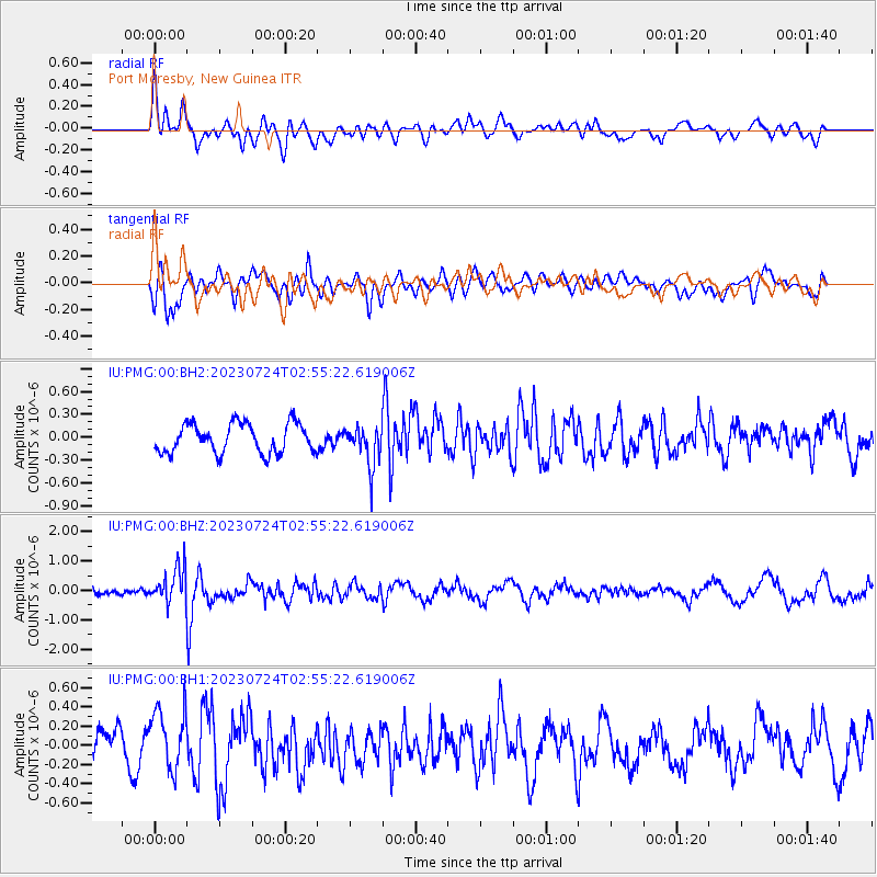
PMG Port Moresby, New Guinea - Earthquake Result Viewer
*The percent match for this event was below the threshold and hence no stack was calculated.
| Earthquake location: |
South Of Fiji Islands |
| Earthquake latitude/longitude: |
-24.2/178.8 |
| Earthquake time(UTC): |
2023/07/24 (205) 02:49:58 GMT |
| Earthquake Depth: |
553 km |
| Earthquake Magnitude: |
6.0 mww |
| Earthquake Catalog/Contributor: |
NEIC PDE/us |
|
| Network: |
IU Global Seismograph Network (GSN - IRIS/USGS) |
| Station: |
PMG Port Moresby, New Guinea |
| Lat/Lon: |
9.40 S/147.16 E |
| Elevation: |
90 m |
|
| Distance: |
33.5 deg |
| Az: |
290.572 deg |
| Baz: |
119.94 deg |
| Ray Param: |
$rayparam |
*The percent match for this event was below the threshold and hence was not used in the summary stack. |
|
| Radial Match: |
70.103165 % |
| Radial Bump: |
400 |
| Transverse Match: |
72.43107 % |
| Transverse Bump: |
400 |
| SOD ConfigId: |
30536071 |
| Insert Time: |
2023-08-07 03:05:21.844 +0000 |
| GWidth: |
2.5 |
| Max Bumps: |
400 |
| Tol: |
0.001 |
|
Signal To Noise
| Channel | StoN | STA | LTA |
| IU:PMG:00:BHZ:20230724T02:55:22.619006Z | 3.278445 | 6.131047E-7 | 1.8701083E-7 |
| IU:PMG:00:BH1:20230724T02:55:22.619006Z | 2.2766652 | 3.106365E-7 | 1.3644365E-7 |
| IU:PMG:00:BH2:20230724T02:55:22.619006Z | 1.375061 | 2.6352035E-7 | 1.9164267E-7 |
| Arrivals |
| Ps | |
| PpPs | |
| PsPs/PpSs | |


