You are here: Home > Network List > CU - Caribbean Network (USGS) Stations List
> Station SDDR Presa de Sabaneta, Dominican Republic > Earthquake Result Viewer
SDDR Presa de Sabaneta, Dominican Republic - Earthquake Result Viewer
| Earthquake location: |
Southern Alaska |
| Earthquake latitude/longitude: |
61.3/-149.9 |
| Earthquake time(UTC): |
2018/11/30 (334) 17:29:28 GMT |
| Earthquake Depth: |
43 km |
| Earthquake Magnitude: |
6.6 ml |
| Earthquake Catalog/Contributor: |
NEIC PDE/ak |
|
| Network: |
CU Caribbean Network (USGS) |
| Station: |
SDDR Presa de Sabaneta, Dominican Republic |
| Lat/Lon: |
18.98 N/71.29 W |
| Elevation: |
589 m |
|
| Distance: |
68.1 deg |
| Az: |
90.454 deg |
| Baz: |
329.364 deg |
| Ray Param: |
0.056450855 |
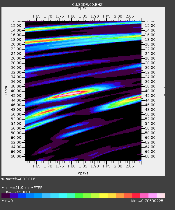
| Estimated Moho Depth: |
41.0 km |
| Estimated Crust Vp/Vs: |
1.80 |
| Assumed Crust Vp: |
6.448 km/s |
| Estimated Crust Vs: |
3.592 km/s |
| Estimated Crust Poisson's Ratio: |
0.27 |
|
| Radial Match: |
83.1016 % |
| Radial Bump: |
400 |
| Transverse Match: |
78.2929 % |
| Transverse Bump: |
400 |
| SOD ConfigId: |
3165032 |
| Insert Time: |
2018-12-14 17:37:17.385 +0000 |
| GWidth: |
2.5 |
| Max Bumps: |
400 |
| Tol: |
0.001 |
|

Signal To Noise
| Channel | StoN | STA | LTA |
| CU:SDDR:00:BHZ:20181130T17:39:53.249028Z | 53.24685 | 1.2821255E-5 | 2.4078898E-7 |
| CU:SDDR:00:BH1:20181130T17:39:53.249028Z | 14.555863 | 4.1882495E-6 | 2.8773624E-7 |
| CU:SDDR:00:BH2:20181130T17:39:53.249028Z | 17.035099 | 3.1303584E-6 | 1.8375933E-7 |
| Arrivals |
| Ps | 5.3 SECOND |
| PpPs | 17 SECOND |
| PsPs/PpSs | 22 SECOND |


