You are here: Home > Network List > CU - Caribbean Network (USGS) Stations List
> Station TGUH Tegucigalpa, Honduras > Earthquake Result Viewer
TGUH Tegucigalpa, Honduras - Earthquake Result Viewer
| Earthquake location: |
Southern Alaska |
| Earthquake latitude/longitude: |
61.3/-149.9 |
| Earthquake time(UTC): |
2018/11/30 (334) 17:29:28 GMT |
| Earthquake Depth: |
43 km |
| Earthquake Magnitude: |
6.6 ml |
| Earthquake Catalog/Contributor: |
NEIC PDE/ak |
|
| Network: |
CU Caribbean Network (USGS) |
| Station: |
TGUH Tegucigalpa, Honduras |
| Lat/Lon: |
14.06 N/87.27 W |
| Elevation: |
0.0 m |
|
| Distance: |
64.8 deg |
| Az: |
107.64 deg |
| Baz: |
331.735 deg |
| Ray Param: |
0.058633003 |
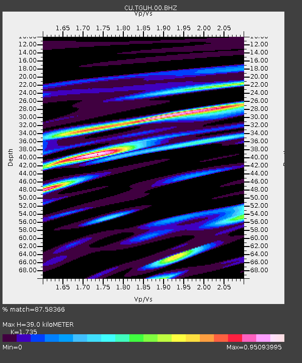
| Estimated Moho Depth: |
39.0 km |
| Estimated Crust Vp/Vs: |
1.74 |
| Assumed Crust Vp: |
6.597 km/s |
| Estimated Crust Vs: |
3.803 km/s |
| Estimated Crust Poisson's Ratio: |
0.25 |
|
| Radial Match: |
87.58366 % |
| Radial Bump: |
400 |
| Transverse Match: |
85.761566 % |
| Transverse Bump: |
400 |
| SOD ConfigId: |
3165032 |
| Insert Time: |
2018-12-14 17:37:19.064 +0000 |
| GWidth: |
2.5 |
| Max Bumps: |
400 |
| Tol: |
0.001 |
|

Signal To Noise
| Channel | StoN | STA | LTA |
| CU:TGUH:00:BHZ:20181130T17:39:32.025029Z | 75.03718 | 1.5533595E-5 | 2.0701196E-7 |
| CU:TGUH:00:BH1:20181130T17:39:32.025029Z | 17.010586 | 3.966208E-6 | 2.3316117E-7 |
| CU:TGUH:00:BH2:20181130T17:39:32.025029Z | 35.74272 | 5.9775934E-6 | 1.6723945E-7 |
| Arrivals |
| Ps | 4.5 SECOND |
| PpPs | 15 SECOND |
| PsPs/PpSs | 20 SECOND |


