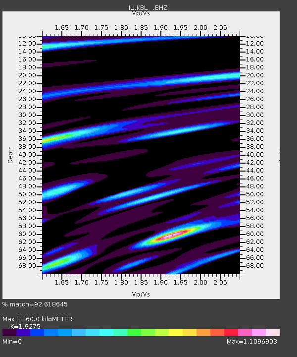
KBL Kabul, Afghanistan - Earthquake Result Viewer
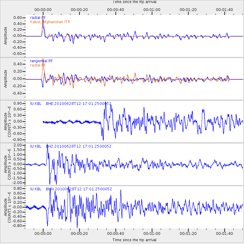
Earthquake location: Southeast Of Honshu, Japan
Earthquake latitude/longitude: 30.7/141.6
Earthquake time(UTC): 2010/06/28 (179) 12:07:25 GMT
Earthquake Depth: 7.0 km
Earthquake Magnitude: 5.5 MS, 5.4 MB, 5.8 MW, 5.7 MW
Earthquake Catalog/Contributor: WHDF/NEIC
Network: IU Global Seismograph Network (GSN - IRIS/USGS)
Station: KBL Kabul, Afghanistan
Lat/Lon: 34.54 N/69.04 E
Elevation: 1920 m
Distance: 60.0 deg
Az: 294.606 deg
Baz: 71.615 deg
Ray Param: 0.06181721
Estimated Moho Depth: 60.0 km
Estimated Crust Vp/Vs: 1.93
Assumed Crust Vp: 6.641 km/s
Estimated Crust Vs: 3.445 km/s
Estimated Crust Poisson's Ratio: 0.32
Radial Match: 92.618645 %
Radial Bump: 400
Transverse Match: 83.64598 %
Transverse Bump: 400
SOD ConfigId: 318645
Insert Time: 2010-11-29 19:49:41.517 +0000
GWidth: 2.5
Max Bumps: 400
Tol: 0.001

Signal To Noise

ChannelStoNSTALTA
IU:KBL: :BHZ:20100628T12:17:01.250005Z20.942749.0486367E-74.320656E-8
IU:KBL: :BHN:20100628T12:17:01.250005Z10.3375543.2569272E-73.1505785E-8
IU:KBL: :BHE:20100628T12:17:01.250005Z11.561334.1976304E-73.63075E-8
Arrivals
Ps8.8 SECOND
PpPs25 SECOND
PsPs/PpSs34 SECOND