You are here: Home > Network List > IU - Global Seismograph Network (GSN - IRIS/USGS) Stations List
> Station CTAO Charters Towers, Australia > Earthquake Result Viewer
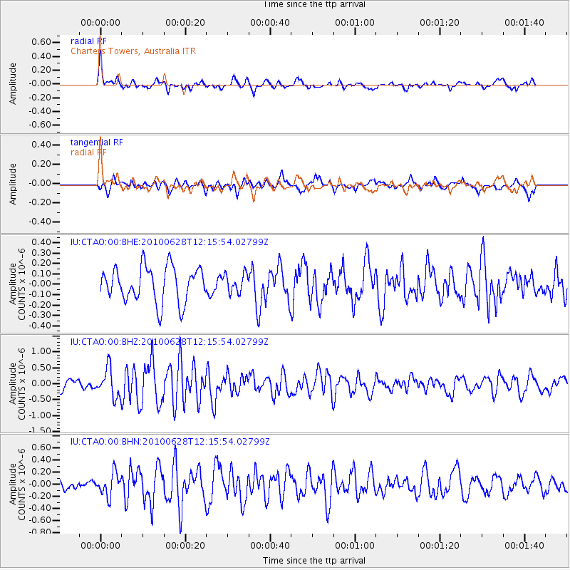
CTAO Charters Towers, Australia - Earthquake Result Viewer
*The percent match for this event was below the threshold and hence no stack was calculated.
| Earthquake location: |
Southeast Of Honshu, Japan |
| Earthquake latitude/longitude: |
30.7/141.6 |
| Earthquake time(UTC): |
2010/06/28 (179) 12:07:25 GMT |
| Earthquake Depth: |
7.0 km |
| Earthquake Magnitude: |
5.5 MS, 5.4 MB, 5.8 MW, 5.7 MW |
| Earthquake Catalog/Contributor: |
WHDF/NEIC |
|
| Network: |
IU Global Seismograph Network (GSN - IRIS/USGS) |
| Station: |
CTAO Charters Towers, Australia |
| Lat/Lon: |
20.09 S/146.25 E |
| Elevation: |
357 m |
|
| Distance: |
50.7 deg |
| Az: |
174.332 deg |
| Baz: |
354.806 deg |
| Ray Param: |
$rayparam |
*The percent match for this event was below the threshold and hence was not used in the summary stack. |
|
| Radial Match: |
75.12664 % |
| Radial Bump: |
313 |
| Transverse Match: |
62.876316 % |
| Transverse Bump: |
400 |
| SOD ConfigId: |
318645 |
| Insert Time: |
2010-11-29 19:49:45.440 +0000 |
| GWidth: |
2.5 |
| Max Bumps: |
400 |
| Tol: |
0.001 |
|
Signal To Noise
| Channel | StoN | STA | LTA |
| IU:CTAO:00:BHZ:20100628T12:15:54.02799Z | 2.732702 | 4.6352076E-7 | 1.6961994E-7 |
| IU:CTAO:00:BHN:20100628T12:15:54.02799Z | 2.3665748 | 1.9452109E-7 | 8.21952E-8 |
| IU:CTAO:00:BHE:20100628T12:15:54.02799Z | 0.5449266 | 9.200395E-8 | 1.6883733E-7 |
| Arrivals |
| Ps | |
| PpPs | |
| PsPs/PpSs | |


