You are here: Home > Network List > G - GEOSCOPE Stations List
> Station KIP Kipapa, Hawai, U.S.A. (Pacific Ocean) > Earthquake Result Viewer
KIP Kipapa, Hawai, U.S.A. (Pacific Ocean) - Earthquake Result Viewer
| Earthquake location: |
Southern Alaska |
| Earthquake latitude/longitude: |
61.3/-149.9 |
| Earthquake time(UTC): |
2018/11/30 (334) 17:29:28 GMT |
| Earthquake Depth: |
43 km |
| Earthquake Magnitude: |
6.6 ml |
| Earthquake Catalog/Contributor: |
NEIC PDE/ak |
|
| Network: |
G GEOSCOPE |
| Station: |
KIP Kipapa, Hawai, U.S.A. (Pacific Ocean) |
| Lat/Lon: |
21.42 N/158.01 W |
| Elevation: |
70 m |
|
| Distance: |
40.3 deg |
| Az: |
191.696 deg |
| Baz: |
6.023 deg |
| Ray Param: |
0.07439812 |
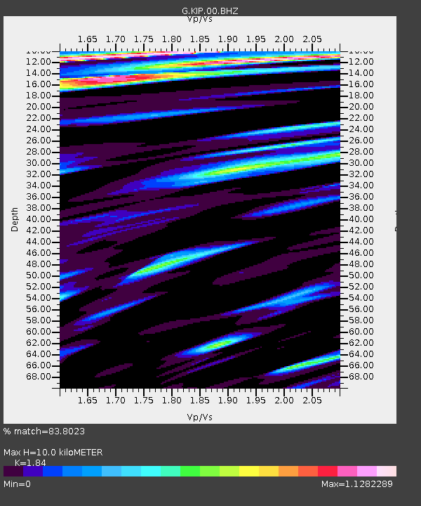
| Estimated Moho Depth: |
10.0 km |
| Estimated Crust Vp/Vs: |
1.84 |
| Assumed Crust Vp: |
4.24 km/s |
| Estimated Crust Vs: |
2.304 km/s |
| Estimated Crust Poisson's Ratio: |
0.29 |
|
| Radial Match: |
83.8023 % |
| Radial Bump: |
388 |
| Transverse Match: |
73.66136 % |
| Transverse Bump: |
380 |
| SOD ConfigId: |
3165032 |
| Insert Time: |
2018-12-14 17:37:59.599 +0000 |
| GWidth: |
2.5 |
| Max Bumps: |
400 |
| Tol: |
0.001 |
|

Signal To Noise
| Channel | StoN | STA | LTA |
| G:KIP:00:BHZ:20181130T17:36:31.218999Z | 2.0871696 | 1.2629432E-5 | 6.050985E-6 |
| G:KIP:00:BH1:20181130T17:36:31.218999Z | 1.1195934 | 3.3843755E-6 | 3.0228612E-6 |
| G:KIP:00:BH2:20181130T17:36:31.218999Z | 2.9840791 | 6.0247016E-6 | 2.0189484E-6 |
| Arrivals |
| Ps | 2.0 SECOND |
| PpPs | 6.5 SECOND |
| PsPs/PpSs | 8.6 SECOND |


