You are here: Home > Network List > G - GEOSCOPE Stations List
> Station TAOE Taiohae, Marquises islands > Earthquake Result Viewer
TAOE Taiohae, Marquises islands - Earthquake Result Viewer
| Earthquake location: |
Southern Alaska |
| Earthquake latitude/longitude: |
61.3/-149.9 |
| Earthquake time(UTC): |
2018/11/30 (334) 17:29:28 GMT |
| Earthquake Depth: |
43 km |
| Earthquake Magnitude: |
6.6 ml |
| Earthquake Catalog/Contributor: |
NEIC PDE/ak |
|
| Network: |
G GEOSCOPE |
| Station: |
TAOE Taiohae, Marquises islands |
| Lat/Lon: |
8.85 S/140.15 W |
| Elevation: |
800 m |
|
| Distance: |
70.4 deg |
| Az: |
169.733 deg |
| Baz: |
355.01 deg |
| Ray Param: |
0.054938704 |
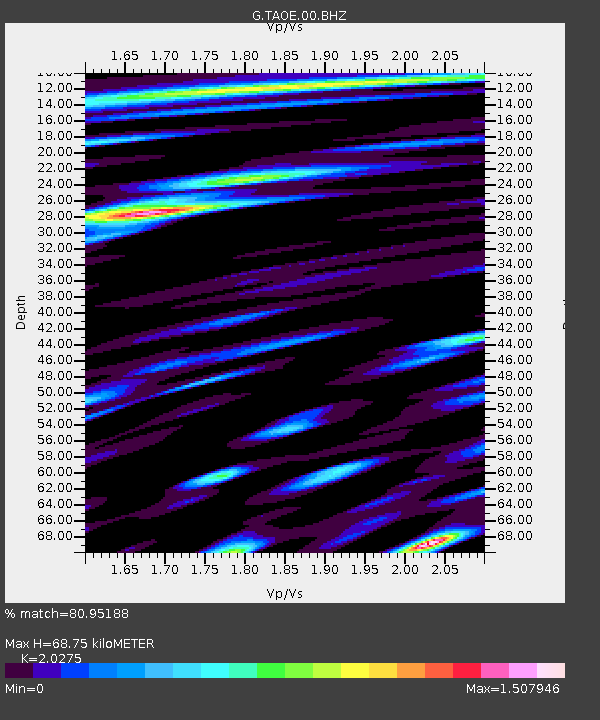
| Estimated Moho Depth: |
68.75 km |
| Estimated Crust Vp/Vs: |
2.03 |
| Assumed Crust Vp: |
4.24 km/s |
| Estimated Crust Vs: |
2.091 km/s |
| Estimated Crust Poisson's Ratio: |
0.34 |
|
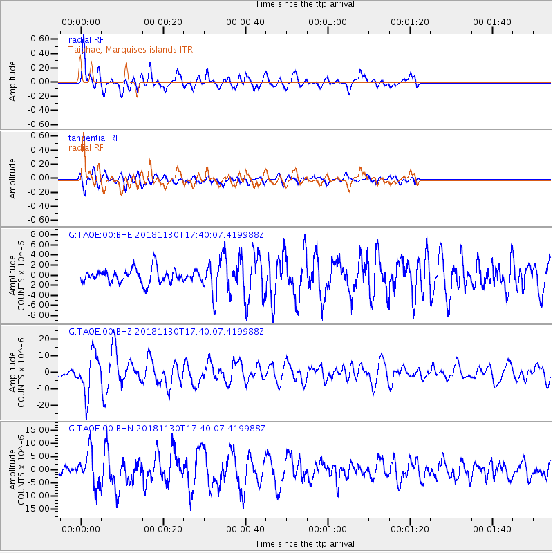
| Radial Match: |
80.95188 % |
| Radial Bump: |
400 |
| Transverse Match: |
65.096504 % |
| Transverse Bump: |
400 |
| SOD ConfigId: |
3165032 |
| Insert Time: |
2018-12-14 17:38:06.818 +0000 |
| GWidth: |
2.5 |
| Max Bumps: |
400 |
| Tol: |
0.001 |
|
Signal To Noise
| Channel | StoN | STA | LTA |
| G:TAOE:00:BHZ:20181130T17:40:07.419988Z | 8.322506 | 1.21911135E-5 | 1.4648367E-6 |
| G:TAOE:00:BHN:20181130T17:40:07.419988Z | 3.8247411 | 6.502612E-6 | 1.7001443E-6 |
| G:TAOE:00:BHE:20181130T17:40:07.419988Z | 2.4937975 | 3.4842315E-6 | 1.3971589E-6 |
| Arrivals |
| Ps | 17 SECOND |
| PpPs | 48 SECOND |
| PsPs/PpSs | 65 SECOND |


