You are here: Home > Network List > TA - USArray Transportable Network (new EarthScope stations) Stations List
> Station M33A Taylor Creek Farms, Clarkson, NE, USA > Earthquake Result Viewer
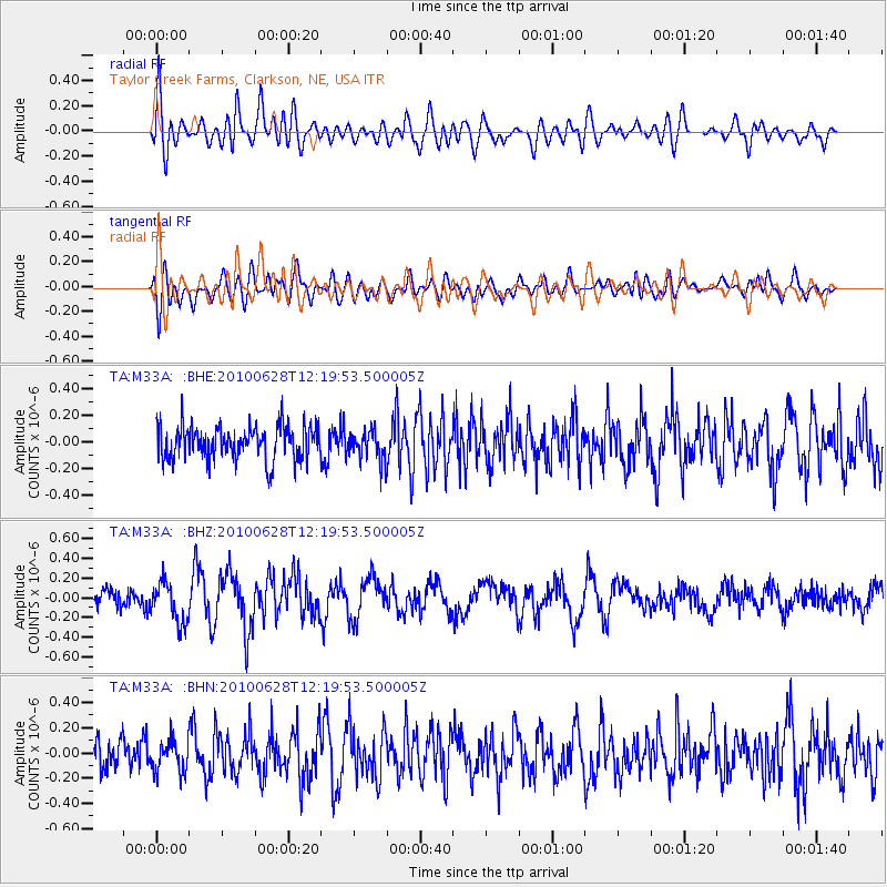
M33A Taylor Creek Farms, Clarkson, NE, USA - Earthquake Result Viewer
*The percent match for this event was below the threshold and hence no stack was calculated.
| Earthquake location: |
Southeast Of Honshu, Japan |
| Earthquake latitude/longitude: |
30.7/141.6 |
| Earthquake time(UTC): |
2010/06/28 (179) 12:07:25 GMT |
| Earthquake Depth: |
7.0 km |
| Earthquake Magnitude: |
5.5 MS, 5.4 MB, 5.8 MW, 5.7 MW |
| Earthquake Catalog/Contributor: |
WHDF/NEIC |
|
| Network: |
TA USArray Transportable Network (new EarthScope stations) |
| Station: |
M33A Taylor Creek Farms, Clarkson, NE, USA |
| Lat/Lon: |
41.57 N/97.19 W |
| Elevation: |
503 m |
|
| Distance: |
90.0 deg |
| Az: |
39.92 deg |
| Baz: |
312.533 deg |
| Ray Param: |
$rayparam |
*The percent match for this event was below the threshold and hence was not used in the summary stack. |
|
| Radial Match: |
64.53535 % |
| Radial Bump: |
400 |
| Transverse Match: |
44.21203 % |
| Transverse Bump: |
400 |
| SOD ConfigId: |
318645 |
| Insert Time: |
2010-11-29 19:52:06.347 +0000 |
| GWidth: |
2.5 |
| Max Bumps: |
400 |
| Tol: |
0.001 |
|
Signal To Noise
| Channel | StoN | STA | LTA |
| TA:M33A: :BHZ:20100628T12:19:53.500005Z | 2.3550966 | 2.0518195E-7 | 8.712252E-8 |
| TA:M33A: :BHN:20100628T12:19:53.500005Z | 0.9050224 | 1.244763E-7 | 1.3753946E-7 |
| TA:M33A: :BHE:20100628T12:19:53.500005Z | 0.879161 | 1.1086244E-7 | 1.2610026E-7 |
| Arrivals |
| Ps | |
| PpPs | |
| PsPs/PpSs | |


