You are here: Home > Network List > GS - US Geological Survey Networks Stations List
> Station DEC05 Apollo Drive Surface Site > Earthquake Result Viewer
DEC05 Apollo Drive Surface Site - Earthquake Result Viewer

| Earthquake location: |
Southern Alaska |
| Earthquake latitude/longitude: |
61.3/-149.9 |
| Earthquake time(UTC): |
2018/11/30 (334) 17:29:28 GMT |
| Earthquake Depth: |
43 km |
| Earthquake Magnitude: |
6.6 ml |
| Earthquake Catalog/Contributor: |
NEIC PDE/ak |
|
| Network: |
GS US Geological Survey Networks |
| Station: |
DEC05 Apollo Drive Surface Site |
| Lat/Lon: |
39.87 N/88.87 W |
| Elevation: |
216 m |
|
| Distance: |
42.4 deg |
| Az: |
91.557 deg |
| Baz: |
321.218 deg |
| Ray Param: |
0.07312348 |
| Estimated Moho Depth: |
31.0 km |
| Estimated Crust Vp/Vs: |
1.67 |
| Assumed Crust Vp: |
6.444 km/s |
| Estimated Crust Vs: |
3.853 km/s |
| Estimated Crust Poisson's Ratio: |
0.22 |
|
| Radial Match: |
89.90649 % |
| Radial Bump: |
400 |
| Transverse Match: |
72.44323 % |
| Transverse Bump: |
400 |
| SOD ConfigId: |
3165032 |
| Insert Time: |
2018-12-14 17:38:32.708 +0000 |
| GWidth: |
2.5 |
| Max Bumps: |
400 |
| Tol: |
0.001 |
|
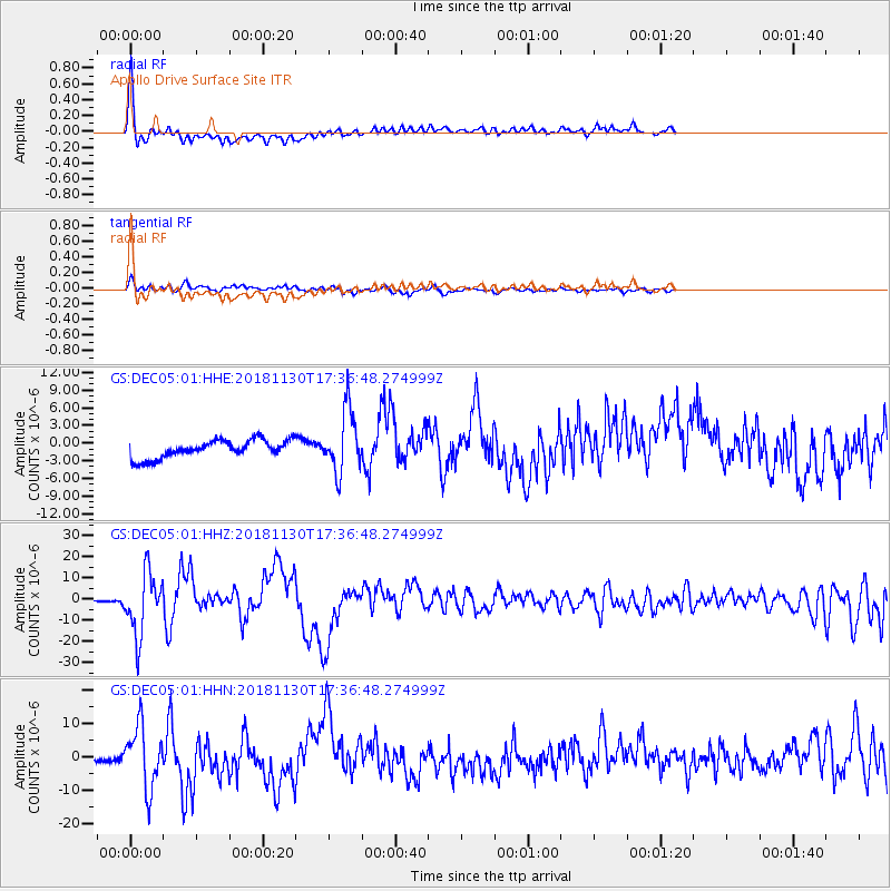
Signal To Noise
| Channel | StoN | STA | LTA |
| GS:DEC05:01:HHZ:20181130T17:36:48.274999Z | 18.37974 | 1.4579504E-5 | 7.932378E-7 |
| GS:DEC05:01:HHN:20181130T17:36:48.274999Z | 8.500592 | 8.992991E-6 | 1.0579253E-6 |
| GS:DEC05:01:HHE:20181130T17:36:48.274999Z | 3.473861 | 5.2399714E-6 | 1.5083999E-6 |
| Arrivals |
| Ps | 3.5 SECOND |
| PpPs | 12 SECOND |
| PsPs/PpSs | 15 SECOND |


